OuachitaMaps Title and Logo

Ouachita National Recreation Trail (OT)

29 free downloadable topo maps of the Ouachita Trail. See below to purchase on weatherproof paper map.

Skip the trail descriptions and jump to the topo maps

The entire trail is now available for Google Earth. See below.

Background. The Ouachita National Recreation Trail is 223 miles stretching from Talimena State Park in Oklahoma to Pinnacle Mountain State Park on the outskirts of Little Rock, Arkansas. The trail stays in the Ouachita National Forest from Oklahoma to Arkansas Highway 9. From there to the end, the trail passes through lands under varied ownership and is administered by Pinnacle Mountain State Park.

While there are maps of the Ouachita Trail, none exist that have the terrain detail available from the USGS 1:24,000 topographic maps and created from GPS tracks. Though I have been intending to hike the trail and produce the same quality maps as the Ozark Highland Trail series, Buffalo River Trail series and the numerous other hike on this website, I have not gotten much past the first 50 miles in Oklahoma. Meanwhile, there have been several intrepid hikers who have tracked all or some of the trail and posted those tracks on the Internet. In addition, Google Earth has high-enough resolution imagery to be able to trace the trail in many sections. and correct some of the GPS error. The tracks of the trail are a composite of that data. See the bottom of the webpage for credits.

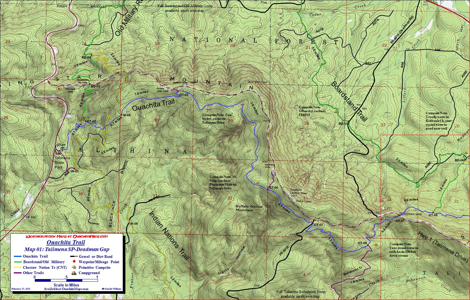
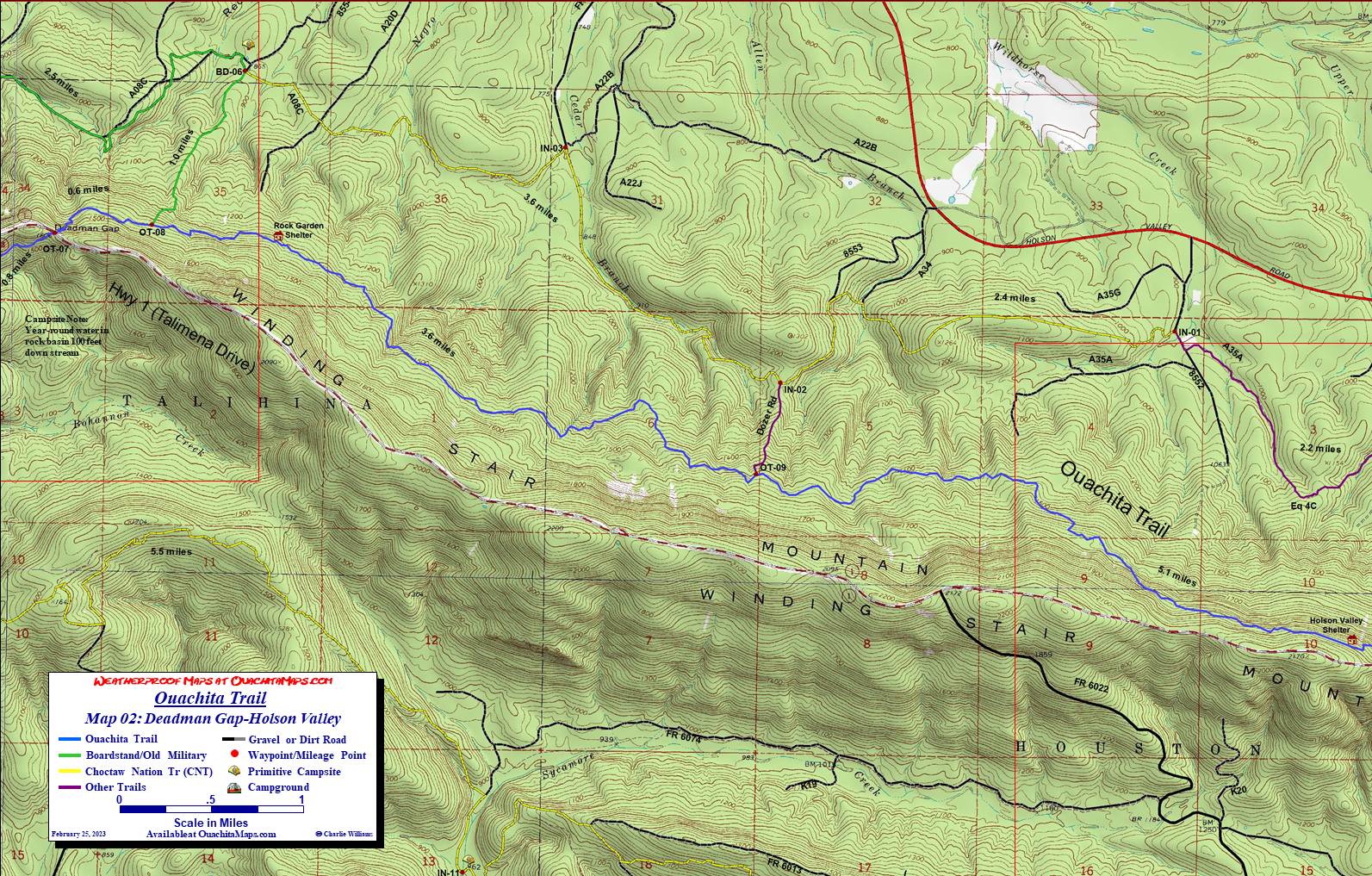
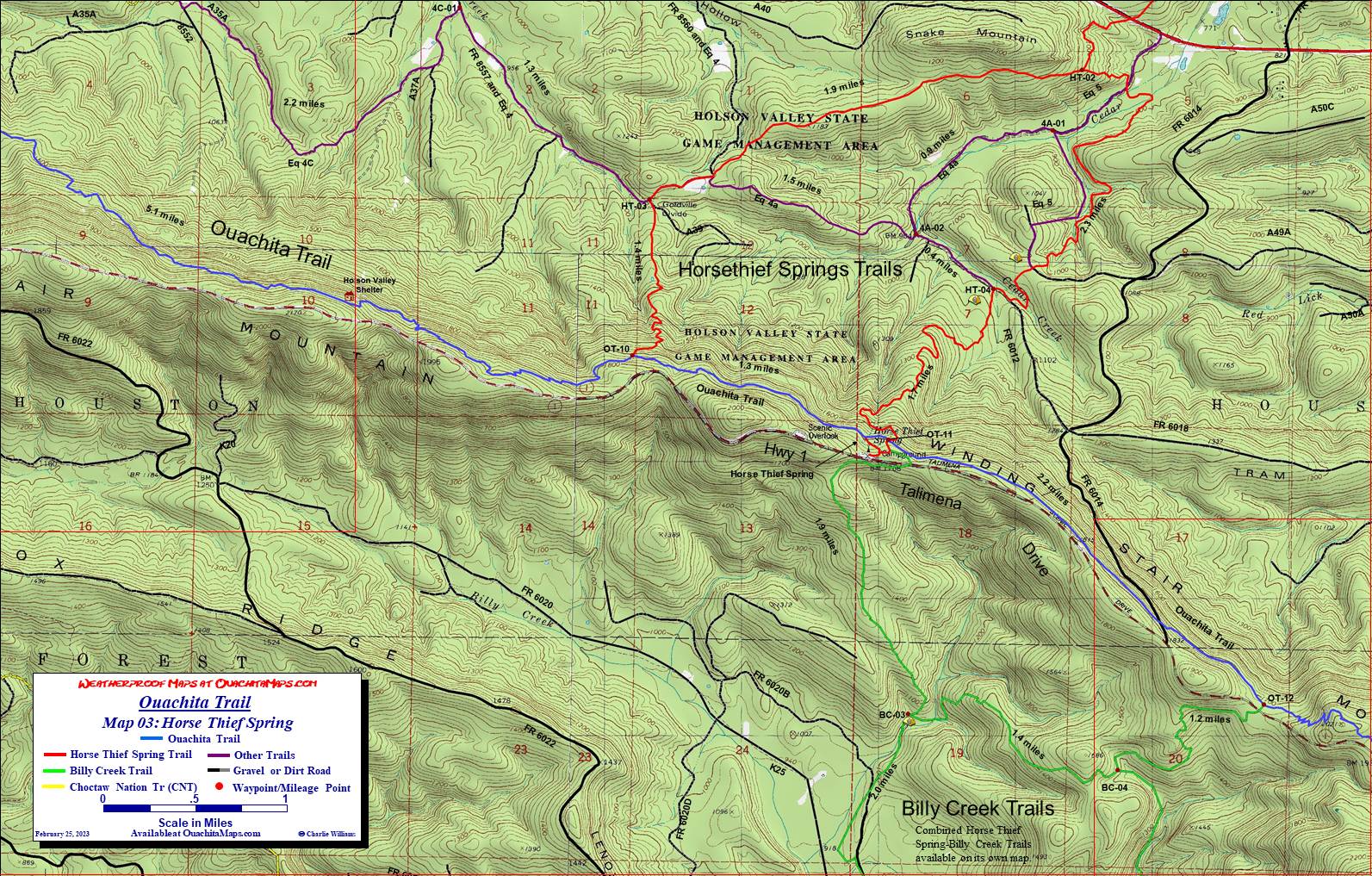
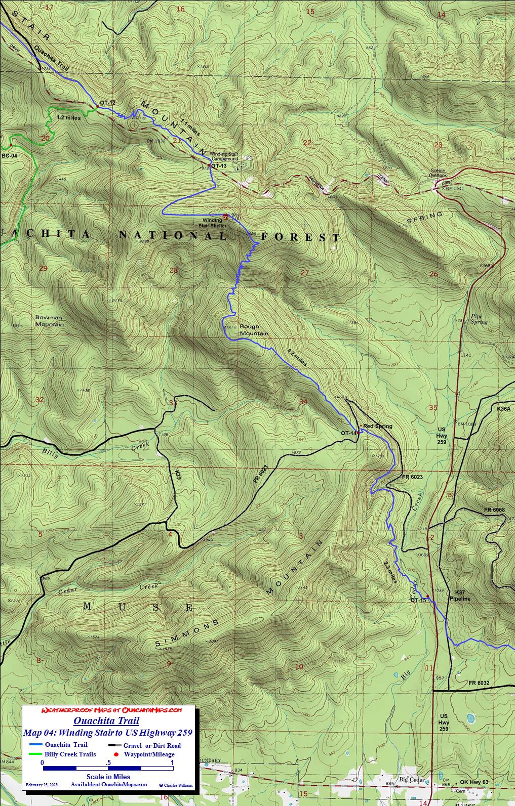
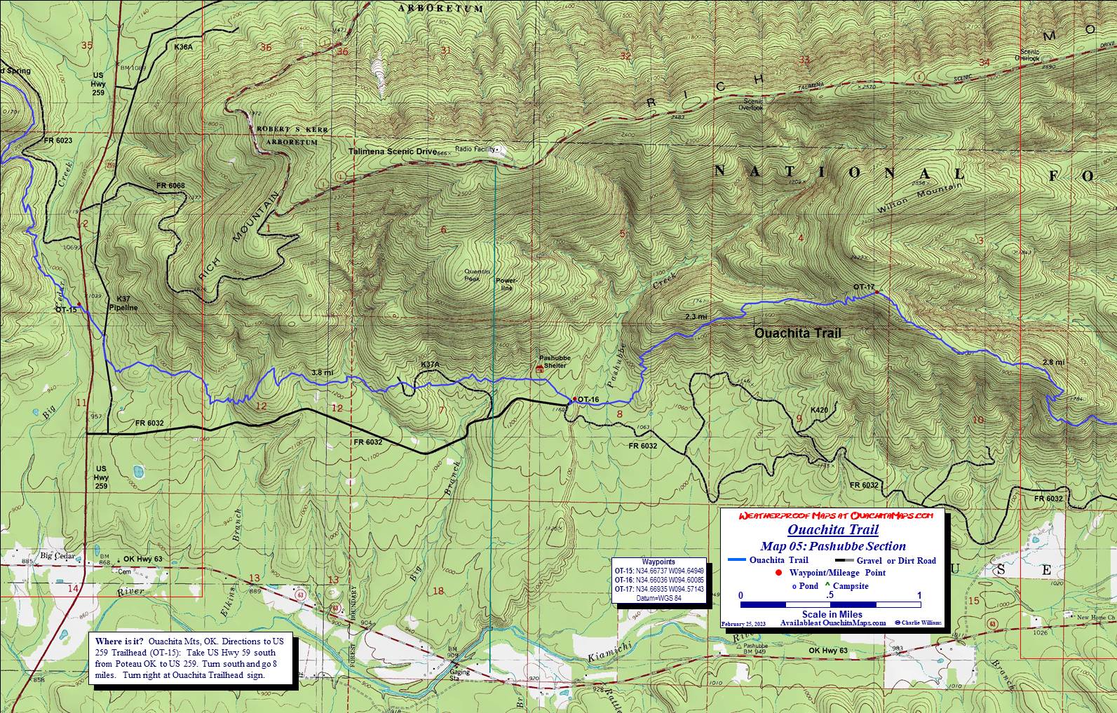
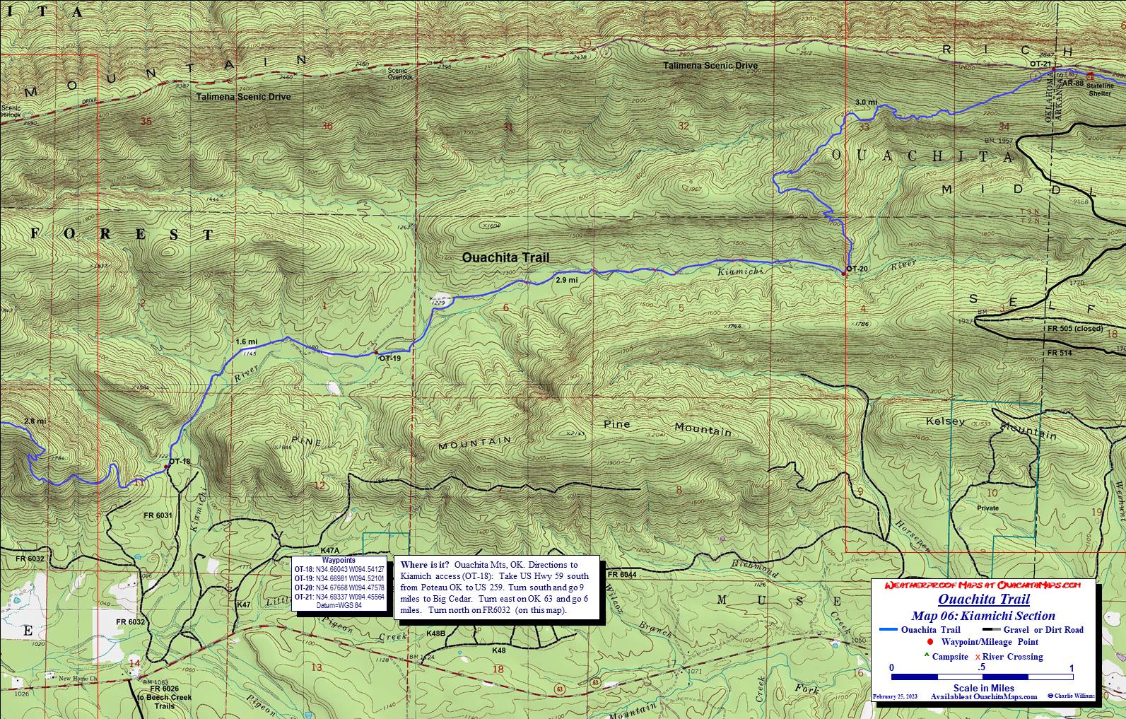
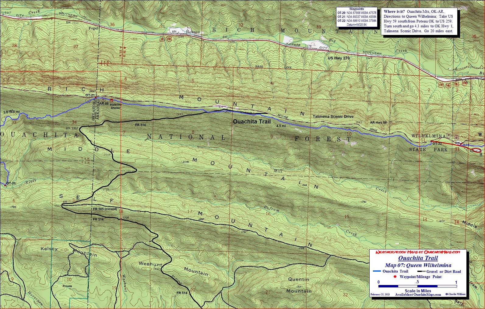
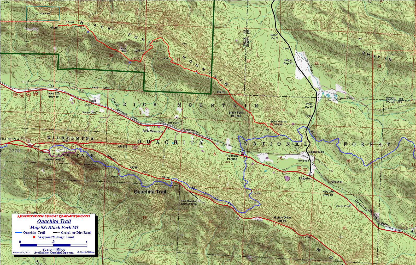
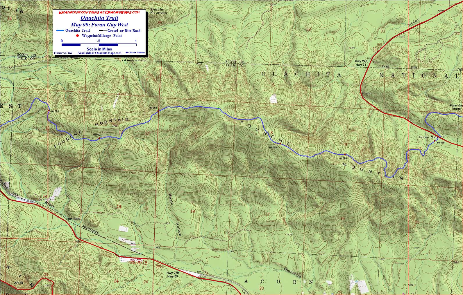
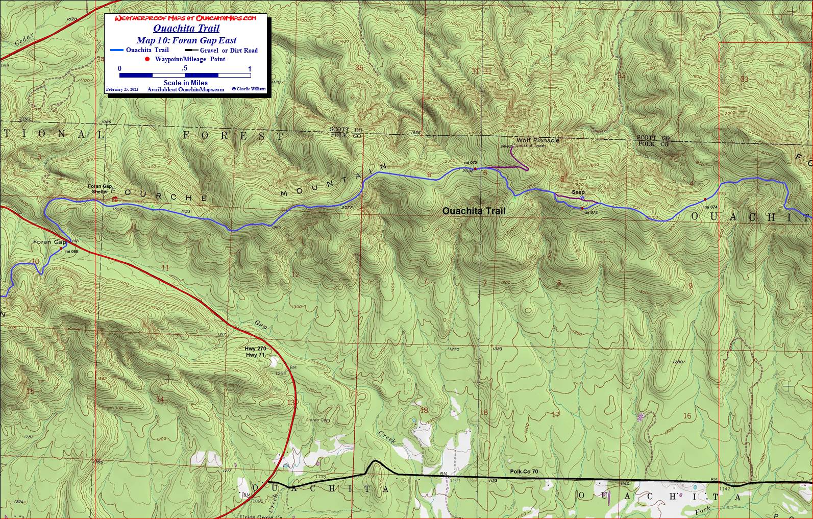
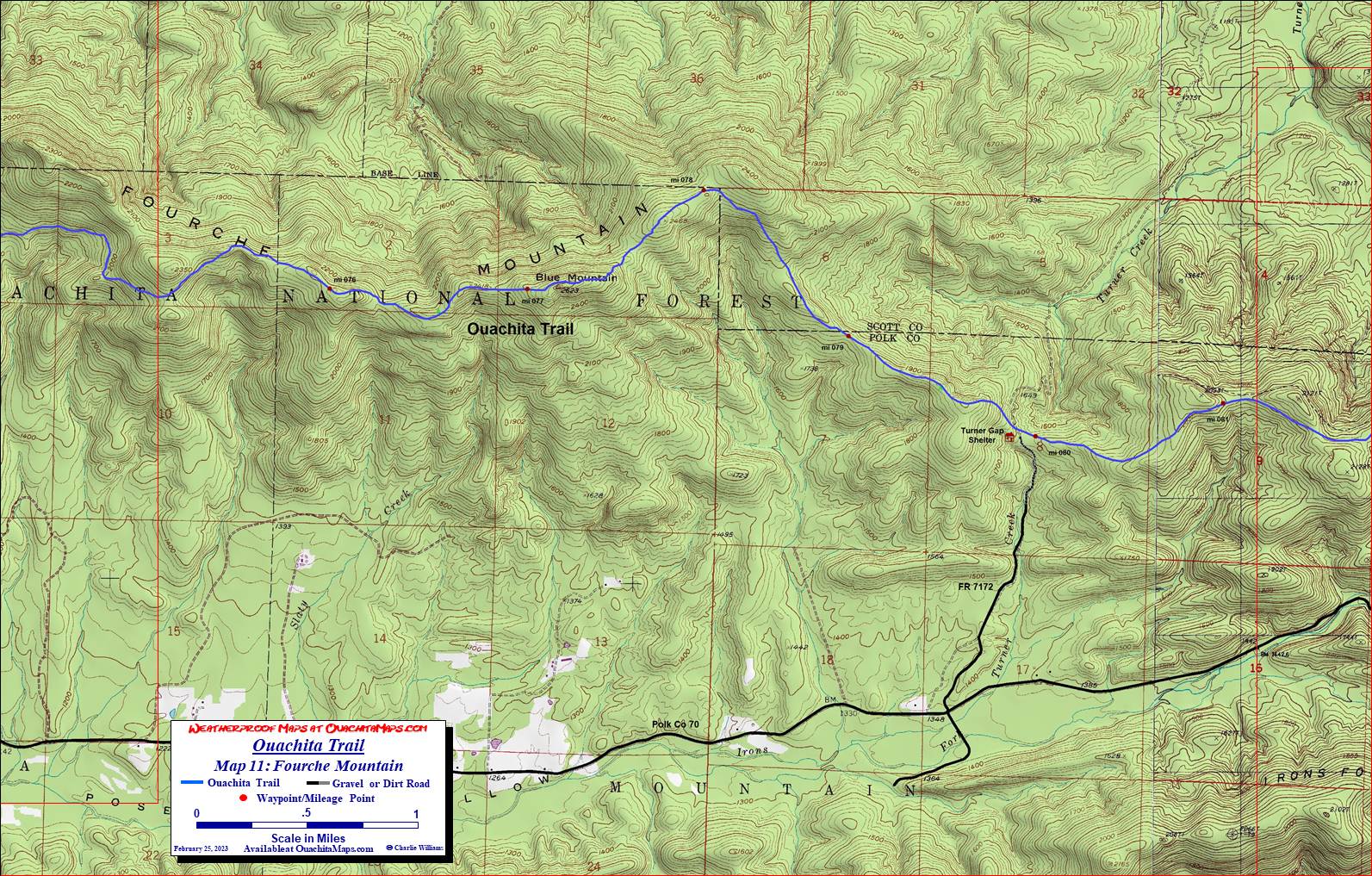
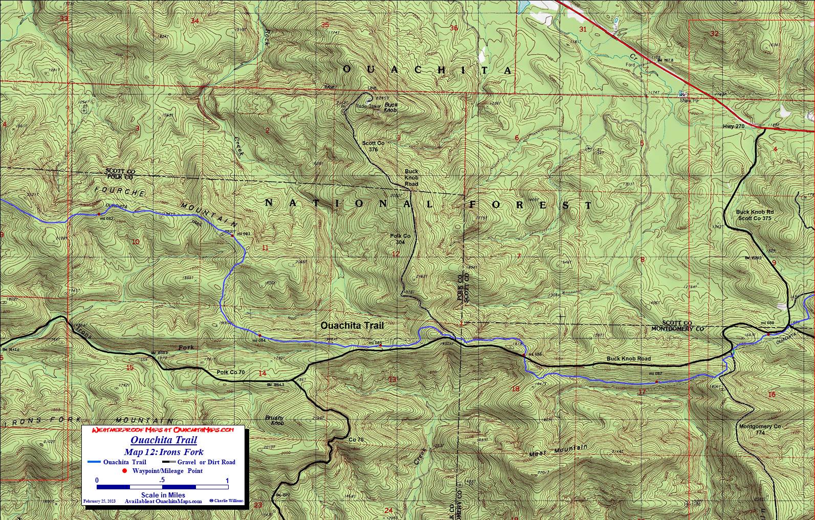
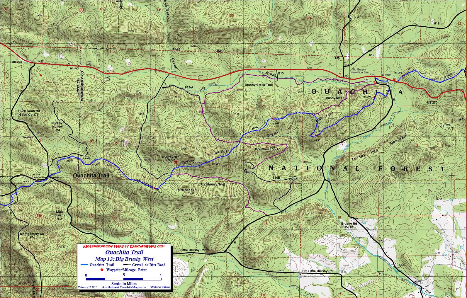
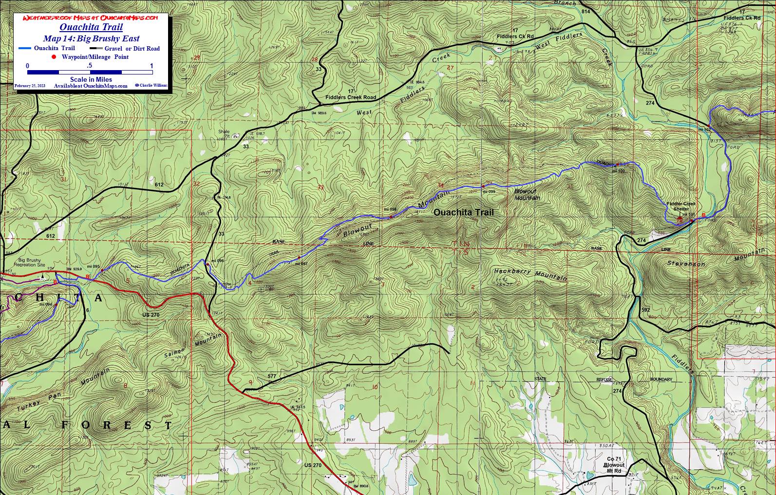
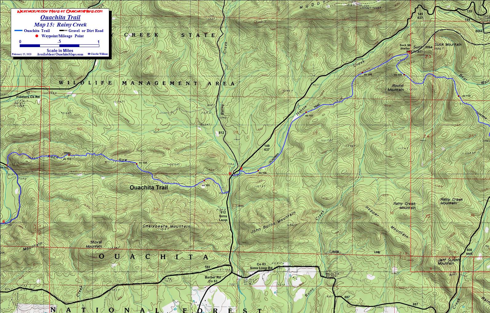
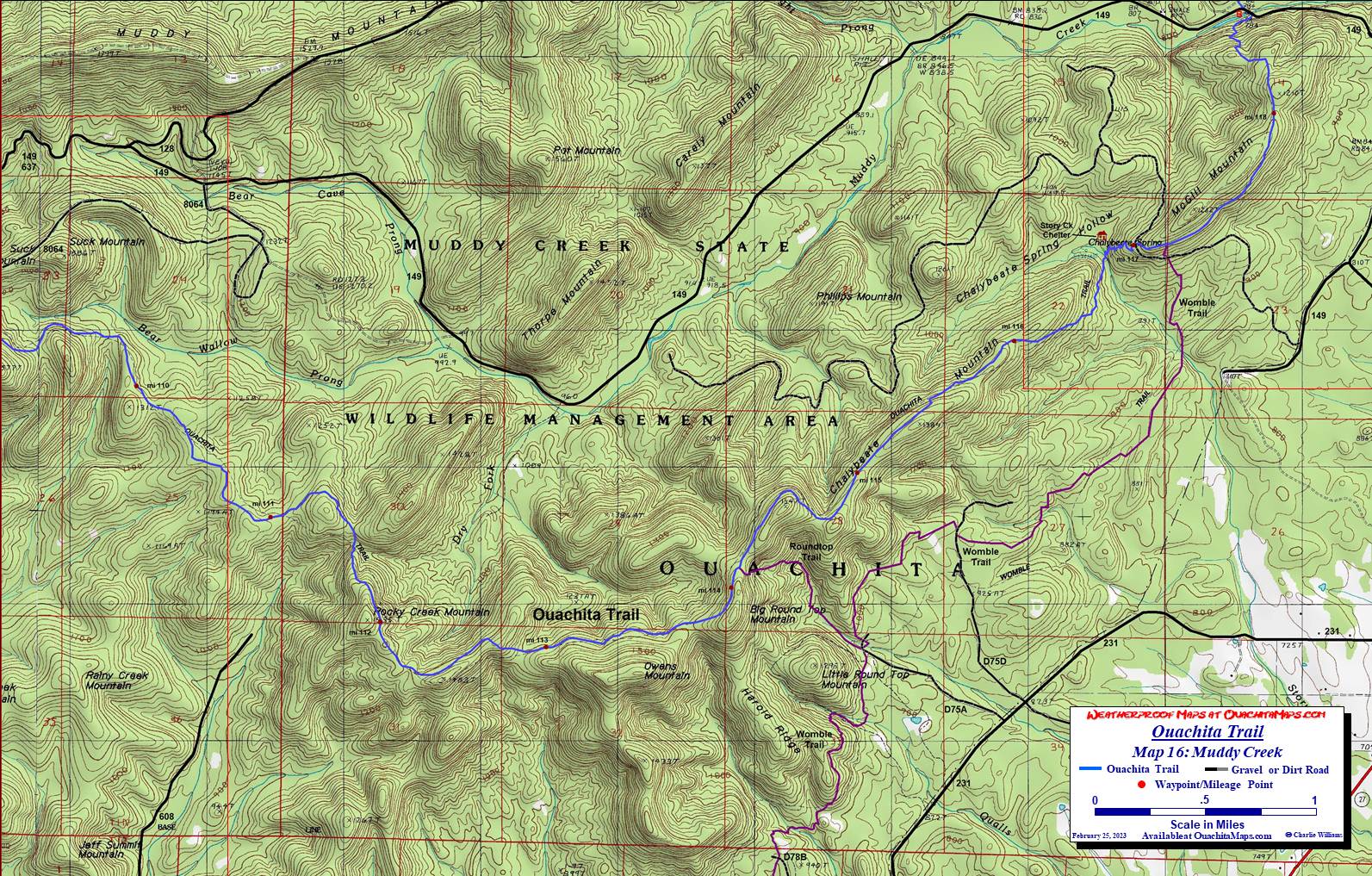
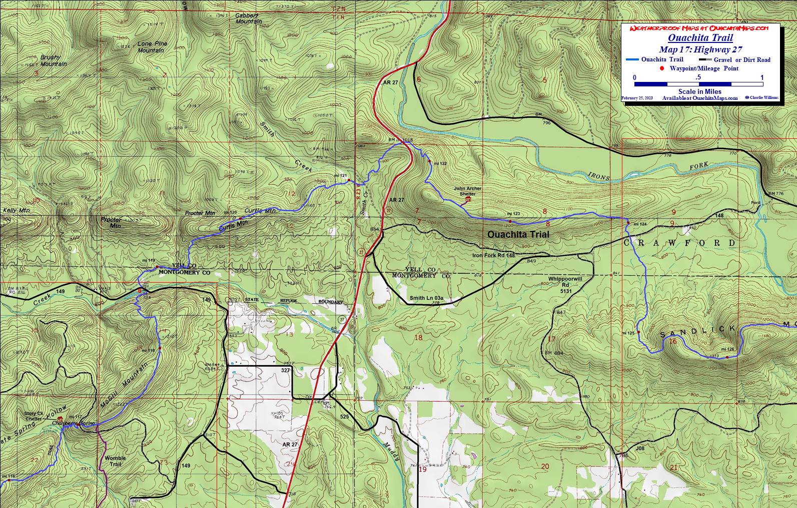
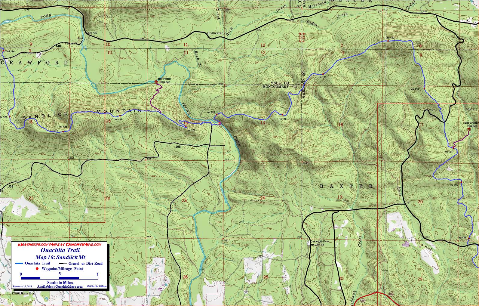
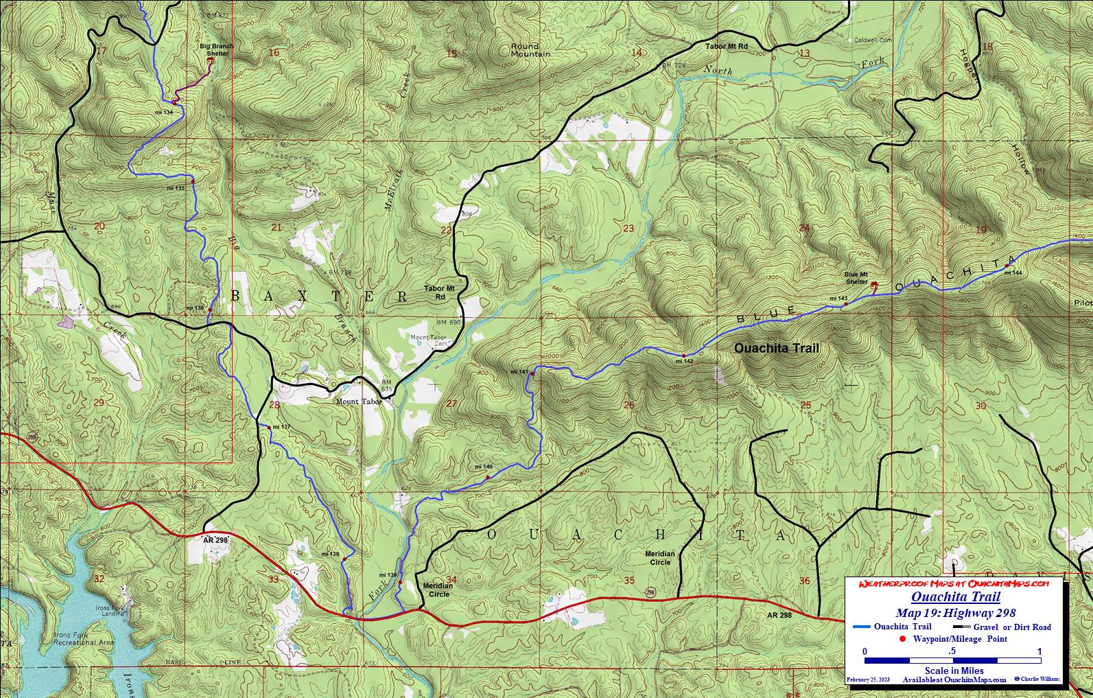
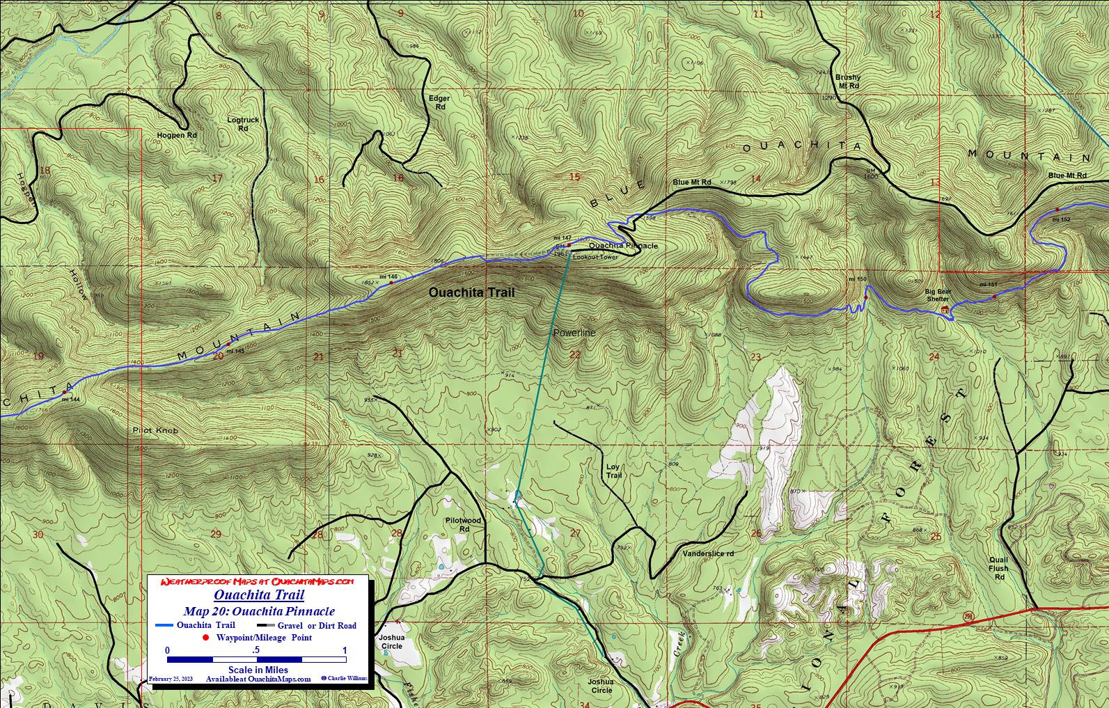
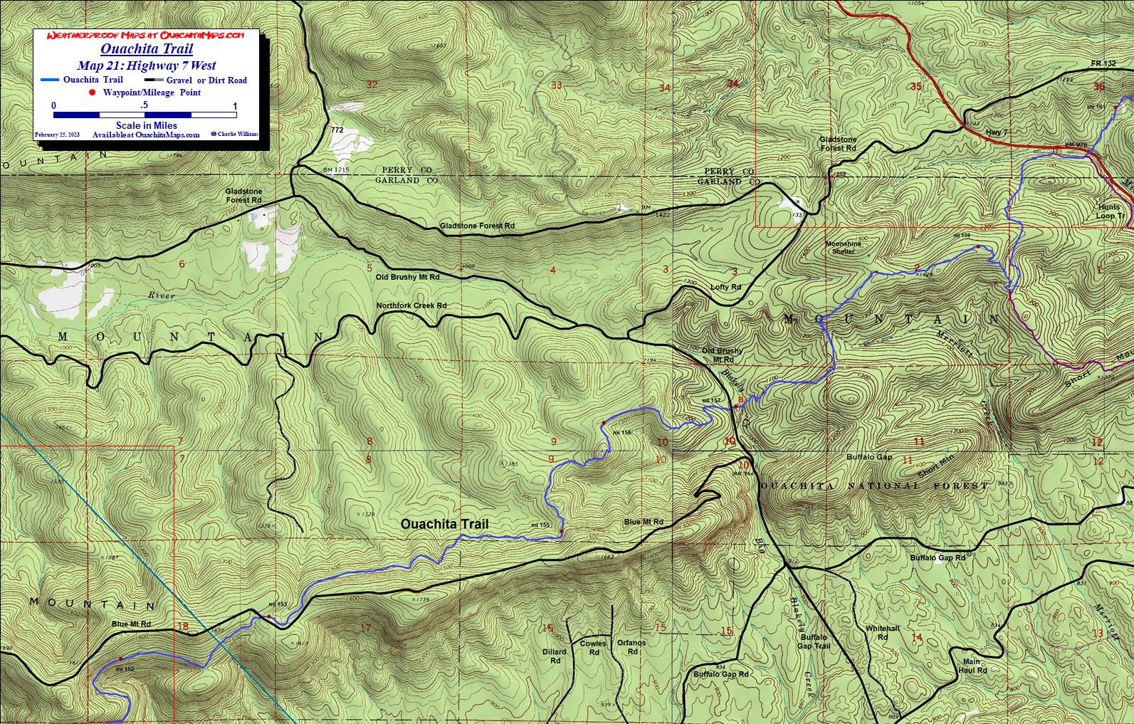
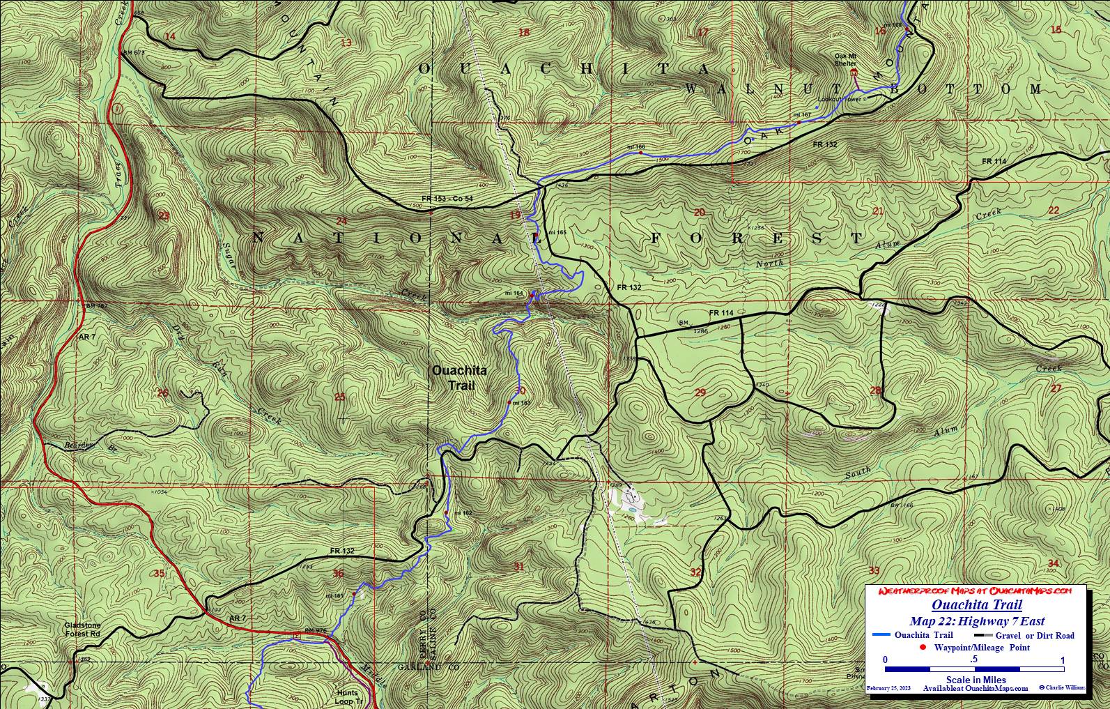
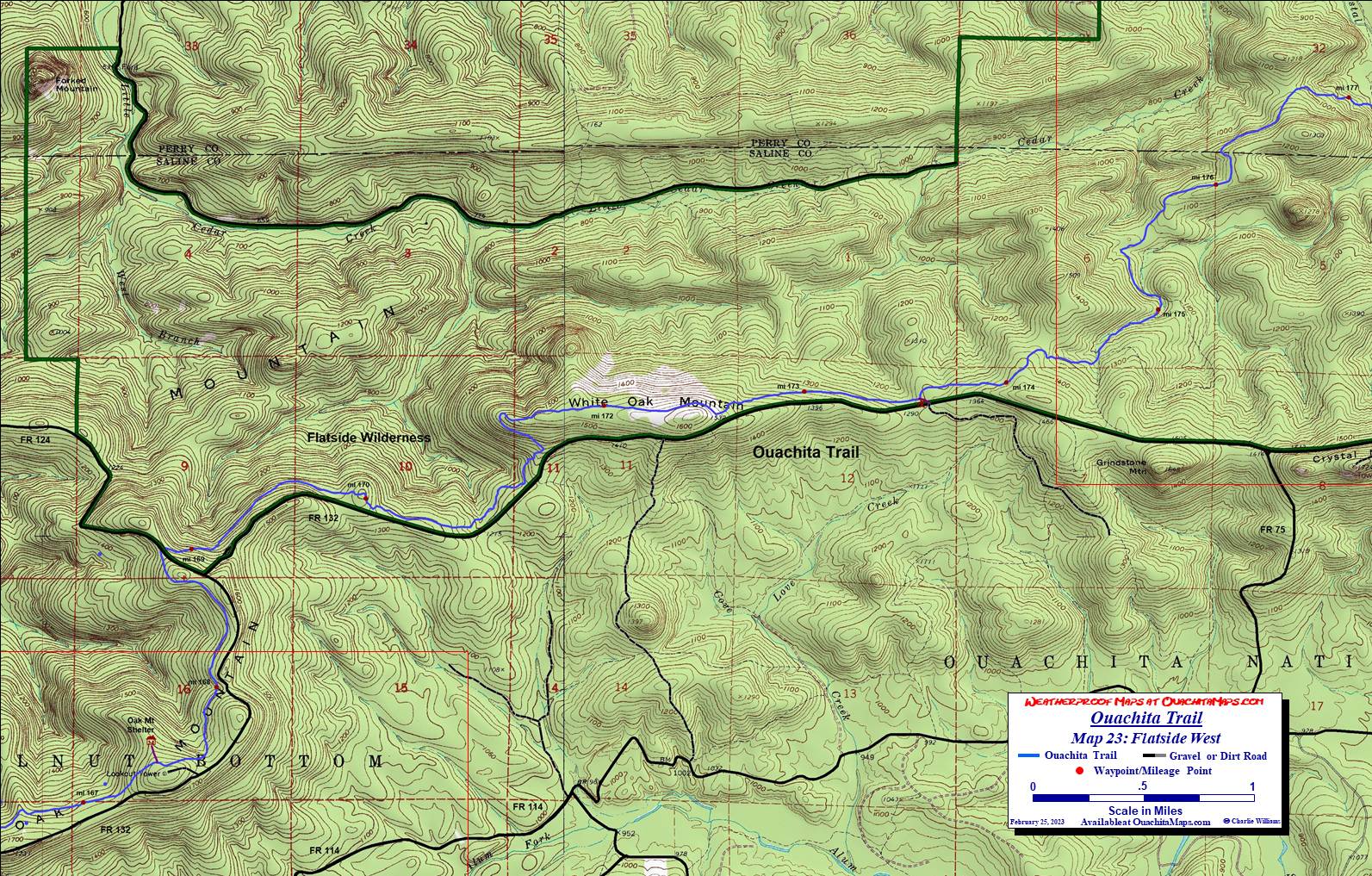
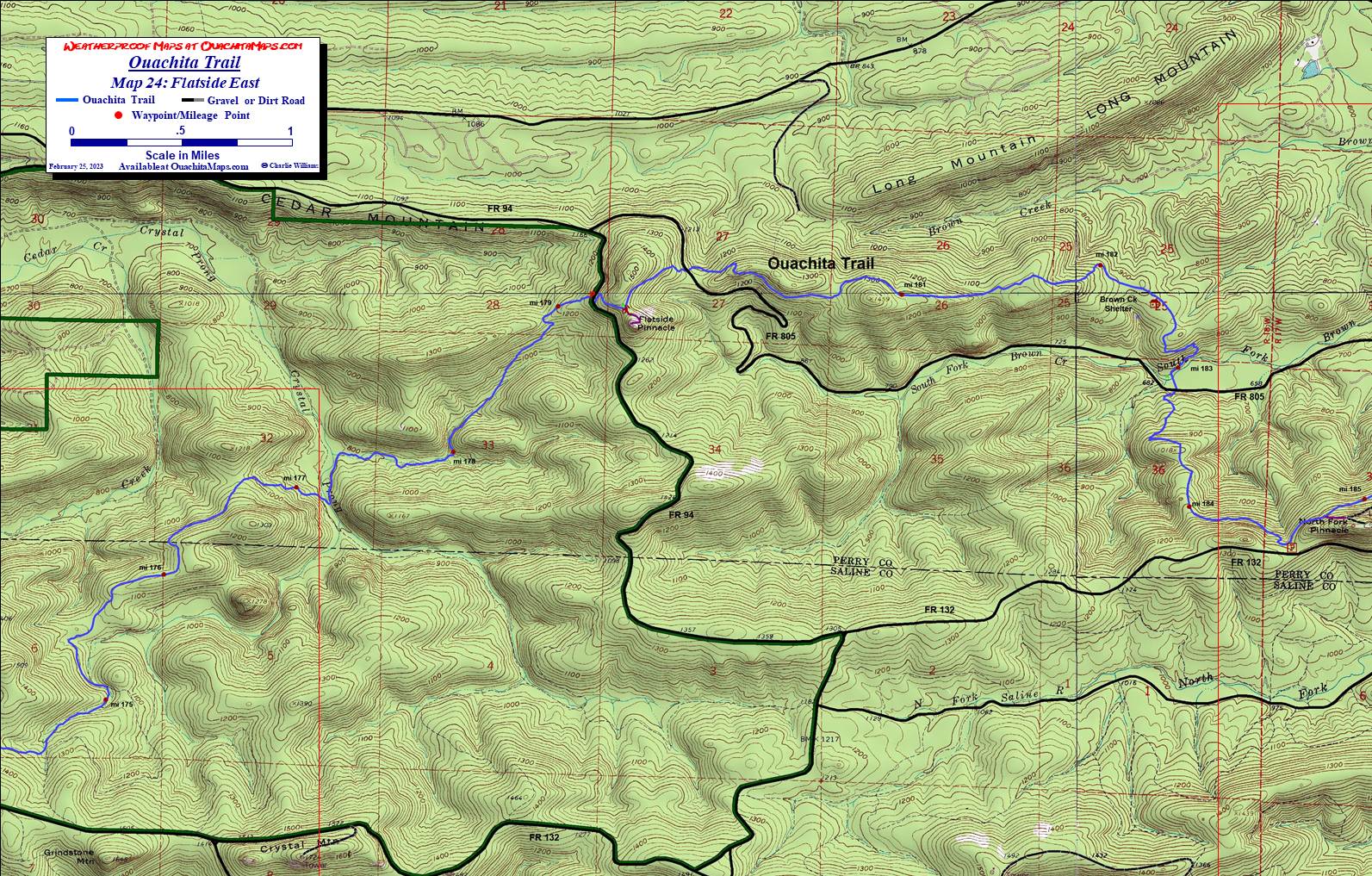
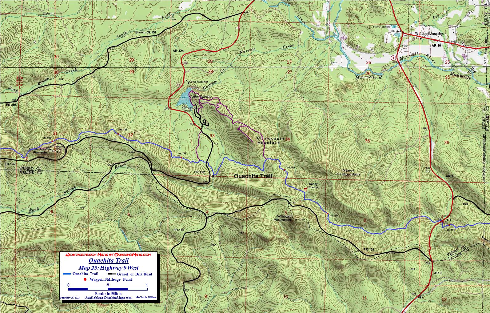
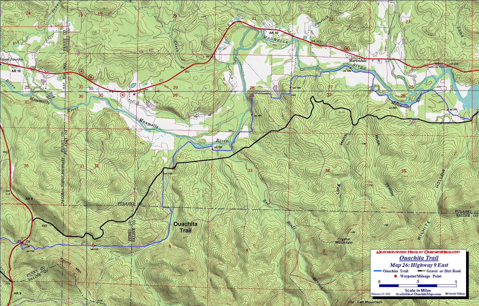
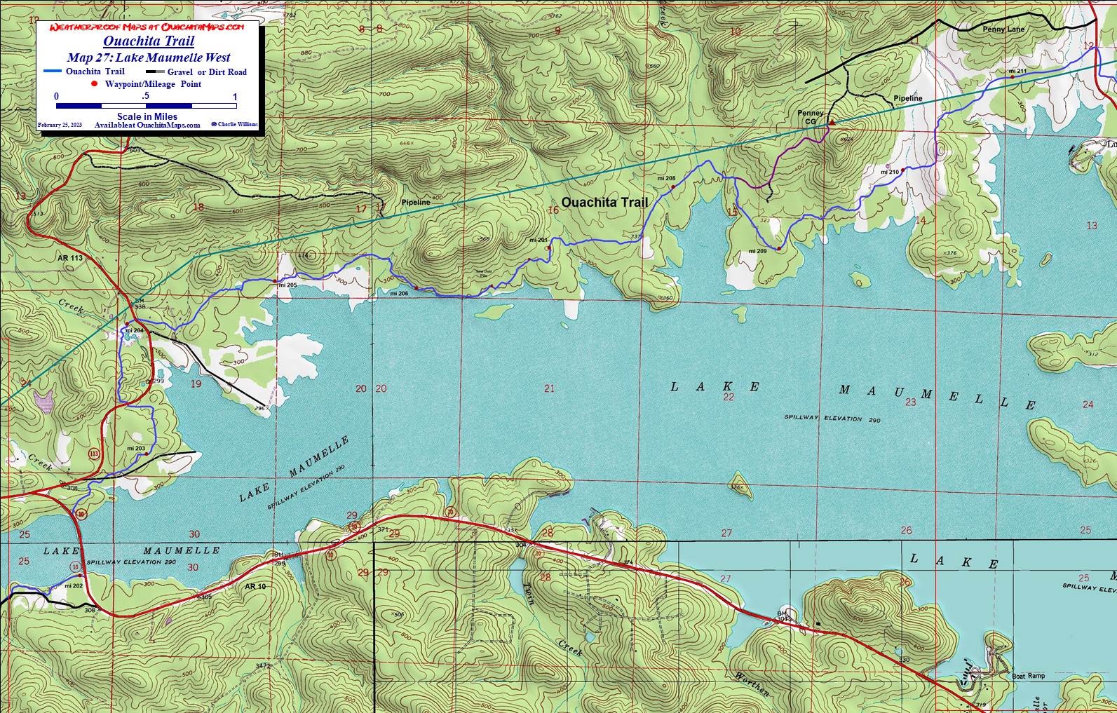
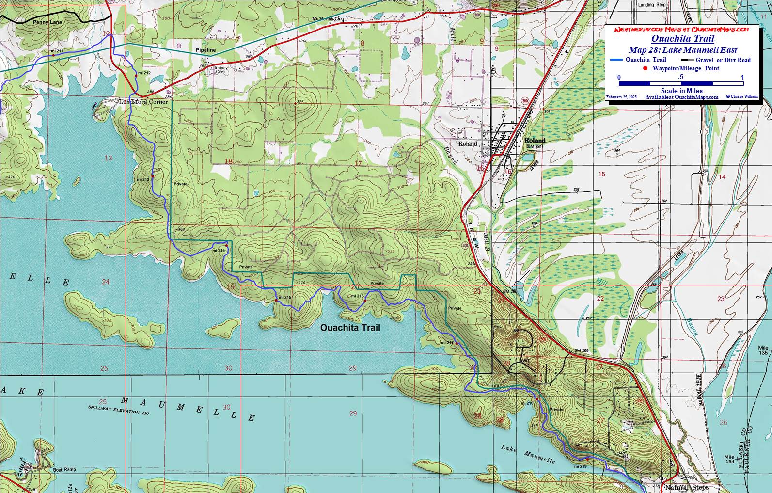
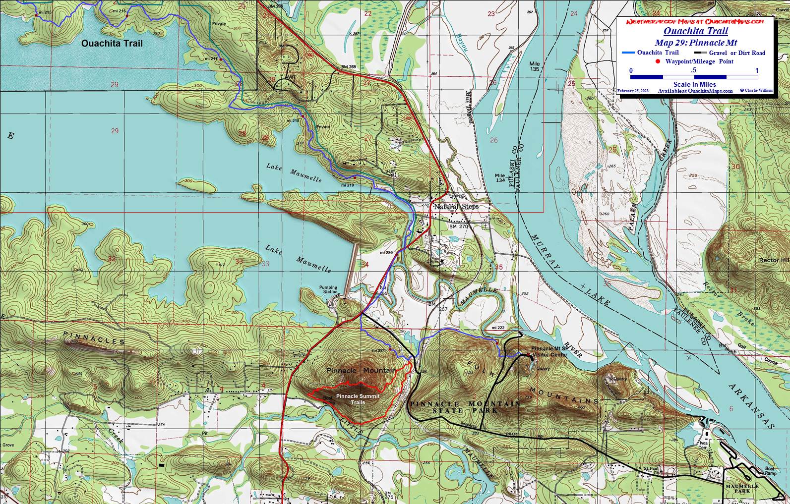
The Maps. The 29 topos are a little further down the page. They begin at Talimena State Park, Oklaahoma and end at Pinnacle Mountain in Arkansas. The maps are free downloads that are formatted to print at scale (1:24,000) on 11 x 17 paper. Click on the image to get to the full size map and right click to download. It is free! Thay are also available printed in color on weather proof, Rite in the Rain, 11 x 17 paper. If you are interested, send me an email (see bottom of page for price and details).

The base maps are a composite of USGS 7.5 minute topos. The OT is shown in blue. Mileage markers where the data was available are provided. The text to the left of the maps show the approximate mileage of the trail and the Friends of the Ouachita Trail (FoOT) trail sections. The maps have been enhanced and updated using aerial photos and satellite imagery.

GPS File: Right click this link and Save Link As to download the GPS tracks in a gpx format. Save it to your computer and use your GPS software to load it to your GPS. There are over 1,000 track points so if it exceeds your saved track capacity, you will need to break up into more digestible bites.

Google Earth Track: Unfortunately Google depreciated the GE API so you can't look at the OT on GE from this website anymore. Instead. right click this link and Save Link As to download the track in the Google Earth kml format. Open the kml file in Google Earth and trace the route in interactive 3D.

Free Detailed Trail Description Available On Line. John (JD) Smith of Frisco, Texas has created a two volume trail description of the west half of the trail. Volume 1 goes from Tamimena State Park (Map 1) to Upper Kiamichi Trailhead at the Oklahoma-Arkansas state line (Map 7). Volume 2 describes the trail from Upper Kiamich to Big Brushy Creek Recreation Area (Map 13).

Improving the maps. While these maps are far better than anything else available, there is always room for improvement. If you have tracks of any section of the trail that you want to share, email me at cew5151@gmail.com. I am missing some of the mile marker locations, shelter locations and spur trail tracks, the campsite site locations of the designated campsites on the east side of Lake Maumelle and there are many section that could use better data. Also, some of the intersecting trails in Arkansas are rough estimates.

OT Map 01: Talimena SP-Deadman Gap.

Trail Description: See Talimena State Park to Winding Stair Rec Area

FoOT Section: 01

Mile Markers: 001 to 009

Highway and road access: US 271, FR 6010, Talimena Dr

Ouachita Trail Map 01 Talimena SP-Deadman Gap.

OT Map 02: Deadman Gap-Holson Valley.

Trail Description: See Talimena State Park to Winding Stair Rec Area

FoOT Section: 01

Mile Markers: 008 to 017

Highway and road access: Talimena Dr, FR 6022

Ouachita Trail Map 02 Deadman Gap-Holson Valley.

OT Map 03: Horse Thief Spring.

Trail Description: See Talimena State Park to Winding Stair Rec Area

FoOT Section: 01 and 02

Mile Markers: 015 to 022

Highway and road access: FR 6014

Ouachita Trail Map 03 Horsethief Spring.

OT Map 04: Winding Stair-US 259.

Trail Description: See Winding Stair Rec Area to US Highway 259

FoOT Section: 02

Mile Markers: 020 to 031

Highway and road access: Talimena Dr, FR 6023, US 259, K37A

See Trail Reports from October 2016

Ouachita Trail Map 04 Winding Stair-US 259.

OT Map 05: Pashubbe.

Trail Description: See US Highway 259 to Queen Wilhelmina State Park

FoOT Section: 02 and 03

Mile Markers: 029 to 038

Highway and road access: US 259, K37A, FR 6032

See Trail Reports from October 2016

Ouachita Trail Map 05 Pashubbe.

OT Map 06: Kiamichi.

Trail Description: See US Highway 259 to Queen Wilhelmina State Park

FoOT Section: 03

Mile Markers: 037 to 046

Highway and road access: FR 6034, Talimena Dr

Ouachita Trail Map 06 Kiamichi.

OT Map 07: Queen Wilhelmina.

Trail Description: See US Highway 259 to Queen Wilhelmina State Park

FoOT Section: 03

Mile Markers: 045 to 051

Highway and road access: Talimena Dr, FR 514, Talimena Dr

See Trail Reports from October 2016

Ouachita Trail Map 07 Queen Wilhelmina.

OT Map 08: Black Fork Mt.

Trail Description: See John Smith's Upper Kiamich to Big Brushy Creek Recreation Area and Black Fork Mt Trail of the Ouachita Trail

FoOT Section: 04

Mile Markers: 051 to 060

Highway and road access: Talimena Dr, US 270/59, FR 516

See Trail Reports from October 2016

Ouachita Trail Map 08 Black Fork Mt.

OT Map 09: Foran Gap West.

Trail Description: See John Smith's Upper Kiamich to Big Brushy Creek Recreation Area

FoOT Section: 04

Mile Markers: 060 to 068

Highway and road access: US 270/71

See Trail Reports from October 2016

Ouachita Trail Map 09 Foran Gap West.

OT Map 10: Foran Gap East.

Trail Description: See John Smith's Upper Kiamich to Big Brushy Creek Recreation Area

FoOT Section: 05

Mile Markers: 068 to 074

Highway and road access: US 270/71

See Trail Reports from October 2016

Ouachita Trail Map 10 Foran Gap East.

OT Map 11: Fourche Mt.

Trail Description: See John Smith's Upper Kiamich to Big Brushy Creek Recreation Area

FoOT Section: 05

Mile Markers: 075 to 081

See Trail Reports from October 2016

Ouachita Trail Map 11 Fourche Mt.

OT Map 12: Irons Fork.

Trail Description: See John Smith's Upper Kiamich to Big Brushy Creek Recreation Area

FoOT Section: 05 and 06

Mile Markers: 082 to 088

Highway and road access: FR 76, FR 48

See Trail Reports from October 2016

Ouachita Trail Map 12 Irons Fork.

OT Map 13: Big Brushy West.

Trail Description: See John Smith's Upper Kiamich to Big Brushy Creek Recreation Area

FoOT Section: 06

Mile Markers: 088 to 095

Highway and road access: FR 76, FR48, FR 813, FR 6, US 270

See Trail Reports from October 2016

Ouachita Trail Map 13 Big Brushy West.

OT Map 14: Big Brushy East.

Trail Description: See Friends of the Ouachita Trail

FoOT Section: 06

Mile Markers: 094 to 101

Ouachita Trail Map 14 Big Brushy East.

OT Map 15: Rainy Creek.

Trail Description: See Friends of the Ouachita Trail

FoOT Section: 07

Mile Markers: 102 to 110

Ouachita Trail Map 15 Rainy Creek.

OT Map 16: Muddy Creek.

Trail Description: See Friends of the Ouachita Trail

FoOT Section: 07

Mile Markers: 109 to 119

Ouachita Trail Map 16 Muddy Creek.

OT Map 17: Highway 27.

Trail Description: See Friends of the Ouachita Trail

FoOT Section: 07 and 08

Mile Markers: 117 to 126

Ouachita Trail Map 17 Highway 27.

OT Map 18: Sandlick Mt.

Trail Description: See Friends of the Ouachita Trail

FoOT Section: 08

Mile Markers: 124 to 135

Ouachita Trail Map 18 Sandlick Mt.

OT Map 19: Highway 298.

Trail Description: See Friends of the Ouachita Trail

FoOT Section: 08

Mile Markers: 134 to 144

Ouachita Trail Map 19 Highway 298.

OT Map 20: Ouachita Pinnacle.

Trail Description: See Friends of the Ouachita Trail

FoOT Section: 09

Mile Markers: 144 to 152

Ouachita Trail Map 20 Ouachita Pinnacle.

OT Map 21: Highway 7 West.

Trail Description: See Friends of the Ouachita Trail

FoOT Section: 09

Mile Markers: 153to 161

Ouachita Trail Map 21 Highway 7.

OT Map 22: Highway 7 East.

Trail Description: See Friends of the Ouachita Trail

FoOT Section: 10

Mile Markers: 160 to 168

Ouachita Trail Map 22 Highway 7 East.

OT Map 23: Flatside West.

Trail Description: See Friends of the Ouachita Trail

FoOT Section: 10

Mile Markers: 167 to 177

Ouachita Trail Map 23 Flatside West.

OT Map 24: Flatside East.

Trail Description: See Friends of the Ouachita Trail

FoOT Section: 10 and 11

Mile Markers: 175 to 185

Ouachita Trail Map 24 Flatside East.

OT Map 25: Highway 9 West.

Trail Description: See Friends of the Ouachita Trail

FoOT Section: 11

Mile Markers: 184 to 192

Ouachita Trail Map 25 Highway 9 West.

OT Map 26 Highway 9 East.

FoOT Section: beyond coverage

Mile Markers: 192 to 201

Ouachita Trail Map 26 Highway 9 East.

OT Map 27 Lake Maumelle West.

FoOT Section: beyond coverage

Mile Markers: 202 to 211

Ouachita Trail Map 27 Lake Maumelle West.

OT Map 28 Lake Maumelle East.

FoOT Section: beyond coverage

Mile Markers: 211 to 219

Ouachita Trail Map 28 Lake Maumelle East.

OT Map 29 Pinnacle Mt.

FoOT Section: beyond coverage

Mile Markers: 216 to 223

Ouachita Trail Map 29 Pinnacle Mt.

Credits: The following are the source of the data used for the maps. The final tracks, however, are a composite and my own interpretation or interpellation of the data so if you find errors while making your own track, it is not their fault.

To Buy Maps: Color weatherproof versions (11x17) of each map are available for $5 each plus S&H by emailing Charlie at cew5151@gmail.com (you will proably need to cut and paste the address into your email app). A 20% discount is available if you want the entire set. That is $4.00 per sheet or $133 total, delivered by UPS in the US. Expensive? Yes, but, there are 29 maps and it is much cheaper than the $300+ for the full set of USGS topos, that doesn't even have the trail.