
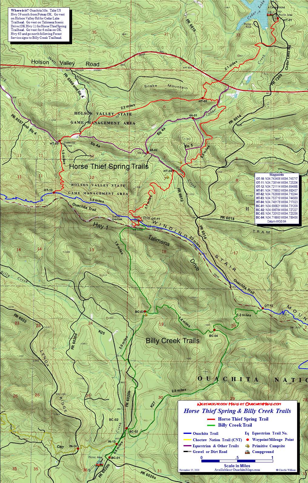
Holson Valley Loop, Ouachita Trail, Oklahoma
Free downloadable topo map of the Holson Loop.
Printed maps are also available for purchase.
This 23 mile loop allows flexible access to the Holson section of the Ouachita Trail (OT) in Oklahoma by combining it with parts of the Boardstand Trail, Choctaw Nation Trail (formerly Indian Nation Trail, INT), Horse Thief Spring Trail and several other trails. It can be done as 2 shorter loop hikes using a short connector trail.
The Map: A free full size version of the map is available on this page as a downloadable jpg. It is also available printed in color on 11x17, "Rite in the Rain” all weather writing paper for $5 plus S&H by emailing Charlie at cew5151@gmail.com. The map is based on USGS 7.5 minute quadrangle topographic maps but has been shrunk to 1:31,700, 2 inches per mile to get it all on one map. FYI, the normal scale of the 7.5 minute quads is 1:24,000 or 2.64 inches per mile.
GPS File: Right click this link and Save Link As to download the tracks in a gpx format. Save it to your computer and use your GPS software to load it to your GPS.
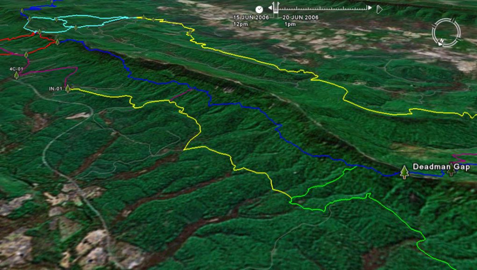
Google Earth Track: Right click this link and Save Link As to download the track in the Google Earth kml format. Save it to your computer, and open it in Google Earth and trace the route in interactive 3D.
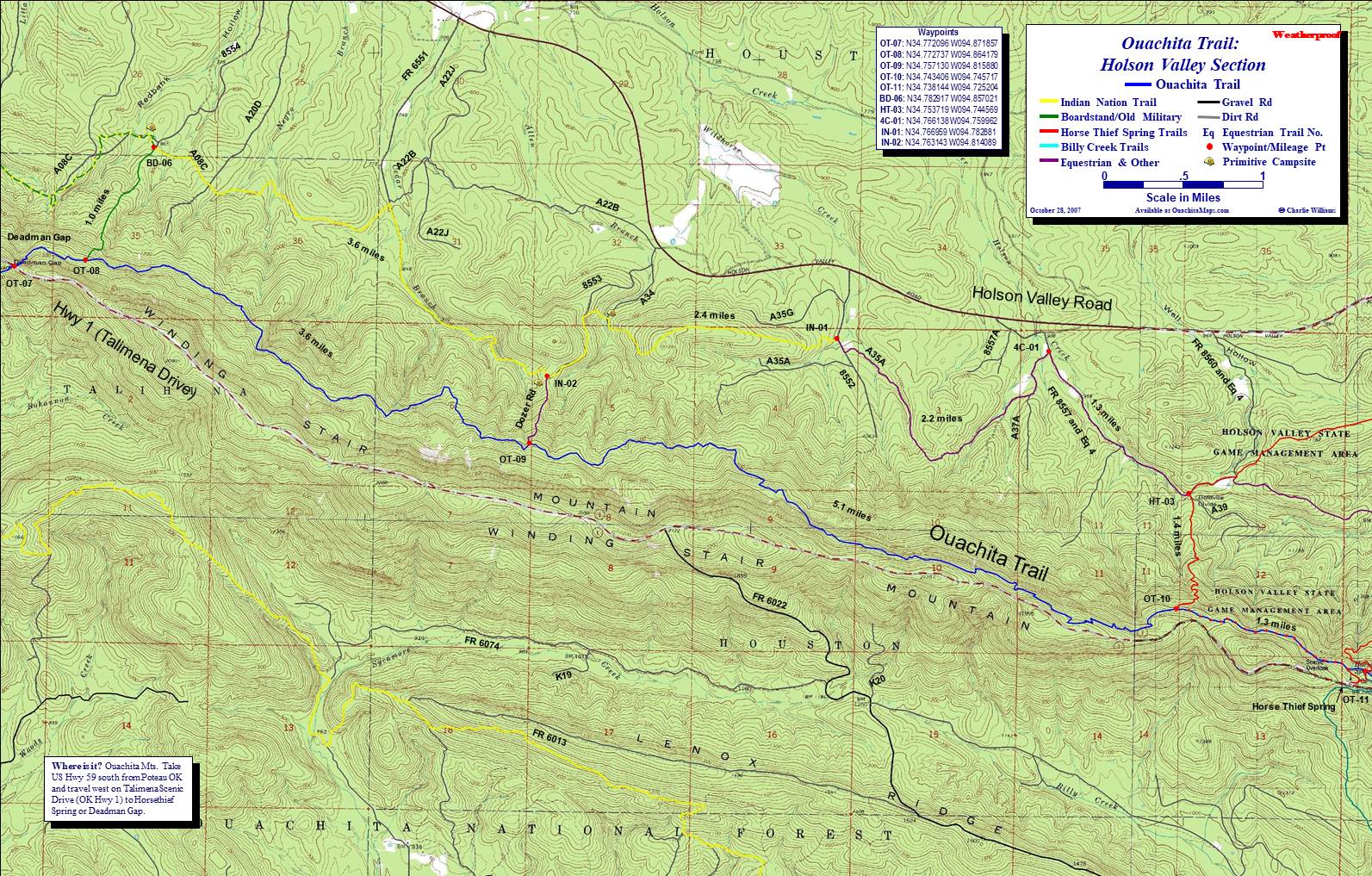
The Hikes: The Holson Valley loop uses the OT, the 4C equestrian trail and the Choctaw Nation Trail. There are several places to begin. To start on the OT, use Horse Thief Spring or Deadman Gap to park off Talimena Drive. To start off of Holson Valley Road, you can use any of the numerous forest roads that cross the CNT. Some that should be reliable are 6551, 8553, 8552 and 8557. The last 3 are closer to Holson Valley Road reducing the chance that you can't make it to the trail crossing. There aren't any parking lots so find a wide spot and pull over.
The narrative of the main loop starts at Deadman's Gap. There is a turnout on Talimena Drive to park. Walk east on the the drive for 0.2 miles to the OT crossing. Go north and follow the OT downhill and to the east. In 0.7 miles is the junction with the Boardstand Trail. You will come up this way at the end of the trip but for now stay on the OT. You are at official mile 8.7 on the OT. Generally, the OT stays on a bench on the north side of Winding Stair Mountain. The trail is often rocky and with the leaves covering it, we dubbed it Ankle Break Pass. It's a misnomer but watch your footing.
In a half mile is the Rock Garden Shelter. The closest water is a wildlife pond about a quarter mile north. Follow the road from the shelter going north and downhill, dropping of about 200 feet. Other than this, there are no perennial streams on this section of the trail. If it has been raining, you will encounter a few little streamlets but if it is summer or fall, they will probably be dry.
Three miles further is the Dozer Road. It is unoffical and there is no sign. For this hike, it is not needed so truck on. In another 4 miles is the Holson Valley Vista Shelter. There is no perennial water.
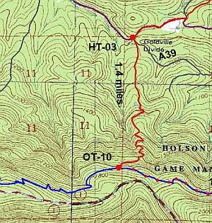
The west Horse Thief trail is in another 1.9 miles. This is waypoint OT-10 on my maps and official OT mile 18.7. For this loop, make a left-hand turn following the white blazes and go north, downhill for for 1.4 miles. You'll come out of the forest at HT-03, the Goldville Divide. The Horse Thief trail and its white blazes continue to the north east but this loop will head off to the west on FR 8557.
It is 1.3 miles to 4C-01. Besides being a forest road, this is also an equestrian trail. If you encounter a horse, it is the hike's responsibility to yield. Move off the trail and speak in a normal voice so the horse knows your are there and doesn't get too excited. At about .95 miles is an open field on the left. At 1.3 miles, there is a second open field on the left. Turn left (west) on the equestrian trail just before it.
This section is the 4C equestrian trail and is about 2.2 miles long. It starts on A37A but at 0.3 miles separates, with the 4C bearing west and the A37A bearing south. 4C will track to the south west for about 1.1 miles and then hook to the northwest for the remaining 1.1 miles. It will come to a "T" intersection with FR 8552. Turn right/north for 0.1 miles to IN-01.
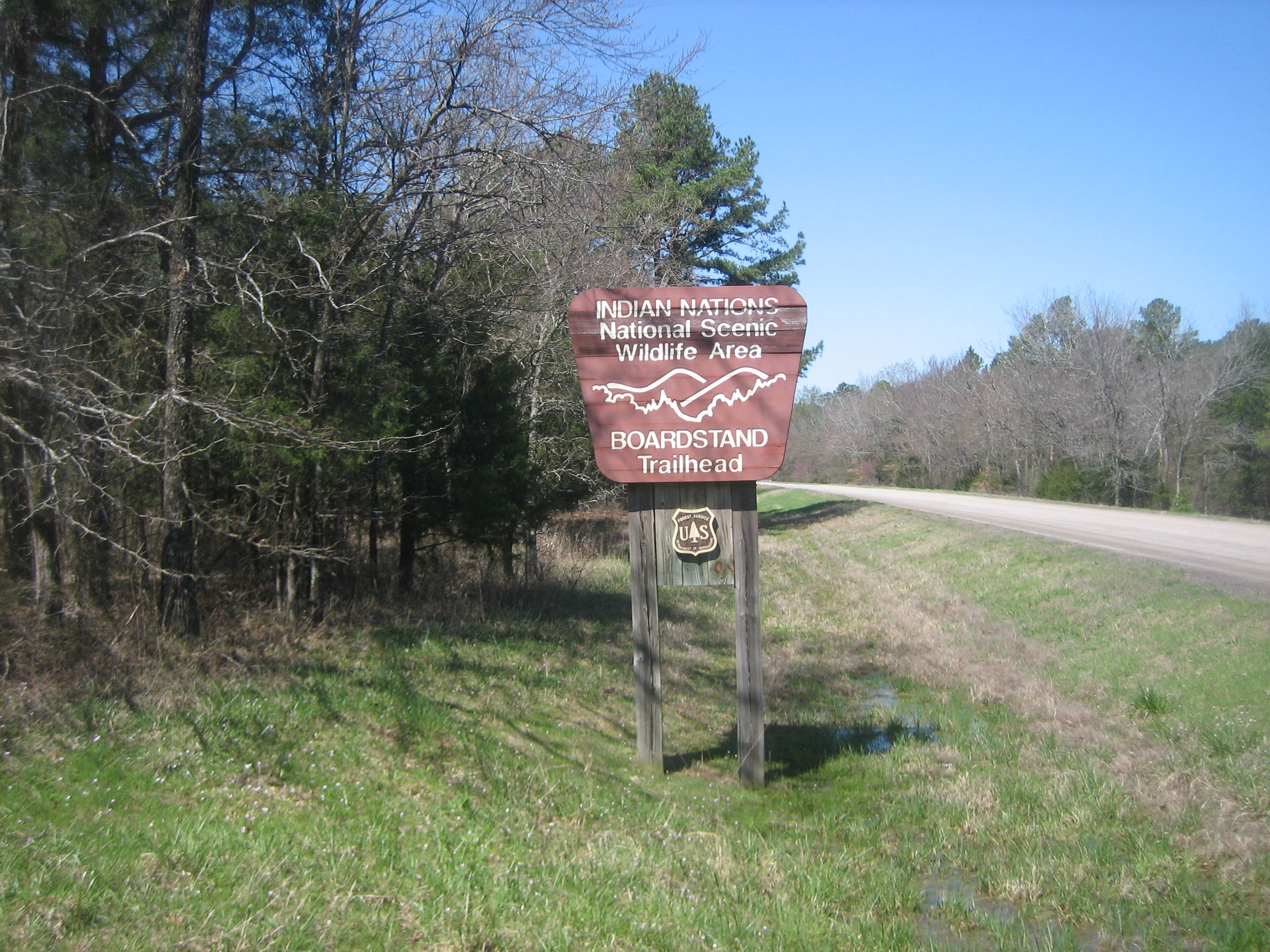
IN-01 is the beginning of the Choctaw Nation Trail (formerly the Indian Nation Trail, hence the IN waypoints). The 43 mile CNT goes west, joining the Boardstand and Old Military trails, south over Winding Stair Mountain brushing by Talimena State Park and then east to the Billy Creek Trailhead. We will be on the CNT for 6 miles.
The CNT goes up the end of an east-west ridge, follows on top for almost 2 miles when it drops down into a tributary of Allen Branch. On the way down the west side you'll encounter A34. We found a good place to camp and water at Allen Branch. Going up the hill on the west side of Allen Branch is FR 8553. Turn left/south for 0.4 miles to IN-02. The 0.4 mile section is level contouring the hill side.
IN-02 is on a saddle and is the other end of the Dozer Road. Although you can take it 0.5 miles back up to the OT, this loop continues downhill to the west. We have camped on the saddle and found water in the Cedar Creek drainage.
It is 1.8 miles to IN-03. The trail follows Cedar Branch and picking up an old forest road after about a mile. At the waypoint, the forest road turns into FR 6551 and the CNT turns left, southwest. About a hundred feet past IN-03 on FR 6551, another forest road comes in from the east. If you get there you missed the turn.
From IN-03 to BD-06 is 1.9 miles. The trail goes southwest, turns towards the east, pops over a small saddle and drops into Negro Branch. It goes over a small nose and then crosses a tributary of Negro Branch. Then there is a small climb to A20D. Across A20D, the CNT joins A08C for the next 0.4 to BD-06.
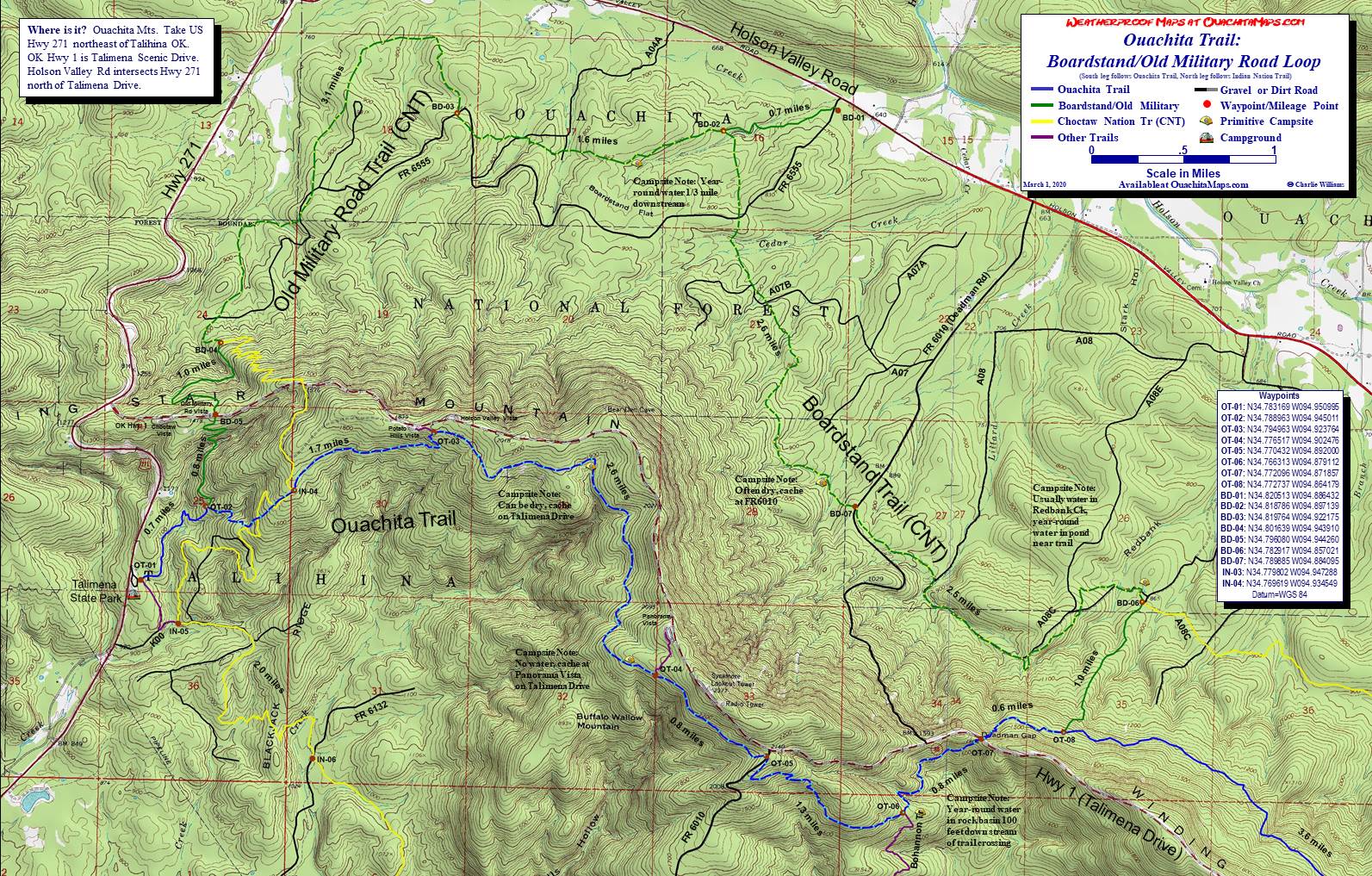
BD-06 it the junction with the Boardstand. Going west, the CNT and Boardstand stay together until the Boardstand becomes the Old Military Road and then finally splits at the bottom of Winding Stair Mountain 10 miles down trail. Going south, the loop is on the spur of the Boardstand that climbs one mile to the OT and waypoint OT-08. Turn right/west on the OT at OT-08 to Talimena Drive and walk back to the Deadman Gap turnout to finish the loop.
In addition to the main loop, we have done some smaller loops, both of which used the Dozer Road. One was to extend the Boardstand loop. We came in from the Boardstand TH on Holson Road (BD-01) and continued on the CNT at BD-06. From IN-02 we hiked up to the OT, went west to OT-07 and crossed Talimena Drive. From there we finished the normal Boardstand-Old Mil loop.
Another trip started at Horse Thief Spring, OT-11 on the Horse Thief-Billy Creek map. We hiked the OT to the Dozer road (OT-09), descended to IN-02 and hiked to Allen Branch to camp. The next day we hiked the equestrian trails to HT-03, and the 4A trails on the Horse Thief-Billy Creek map. Once they were explored we hiked the east Horse Thief trail back to Horse Thief Spring.
Info: USGS 7.5 minute quadrangle topographic maps: LeFlore SE, Muse, Hodgen and Big Cedar (trails not shown). Contact Talimena State Park at (918) 567-2052. Contact the Ouachita National Forest, Choctaw Unit, Hodgen OK, at (918) 653-2991.
Directions to Deadman Gap: Take Arkansas US Hwy. 271 to Talimena Drive (Highway 1) and go east 6 miles. Park at the Deadman Gap Vista on the north side of the highway. Ouachita Trail crosses Talimena Drive a few hundred feet east of the vista.
Directions to Horse Thief Springs: Take US 59 south of Heavener OK to the junction of Hwy 259 junction. Turn right and go 5 miles until the junction of Talimena Drive (Hwy 1). Take Talimena west for about 5 miles. Horse Thief Springs is well marked and on the right.
To Buy Maps: The entire trail is on one map. Color, 11x17 maps on weatherproof paper are available for $5 each plus S&H by emailing Charlie at cew5151@gmail.com (copy and paste in your email).