Choctaw Nation Trail (CNT), Ouachita Mts, Oklahoma
Free downloadable topo maps of the CNT.
Printed maps are also available for purchase.
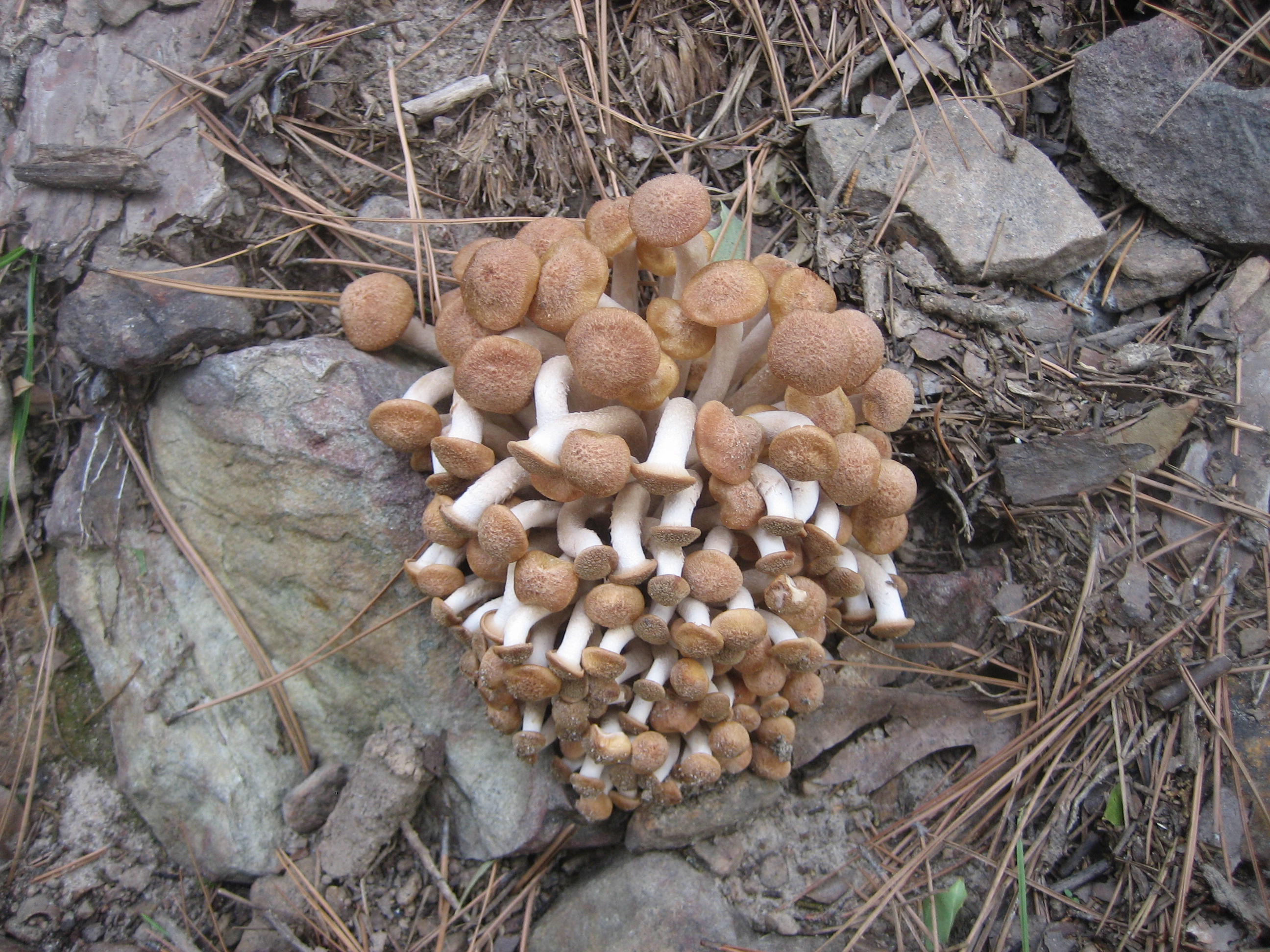
The Choctaw Nation Trail (CNT), formerly the Indian Nation Trail (INT), is a 43 mile multi-use trail that starts in the Holson Valley, goes west towards US Highway 271 and then back east on the southside of Winding Stair Mountain. Its chief value for Ouachita Trail hikers is as a connector to provide more flexibilty in planning trips.
The Maps: A free full size versions of the maps are available on this page as downloadable jpgs. They are also available printed in color on 11x17, "Rite in the Rain” all weather writing paper for $5 per map plus S&H by emailing Charlie at cew5151@gmail.com. The maps are nominal 1:24,000 based on USGS 7.5 minute quadrangle topographic maps except the Holson map which is 1:31,700.
Several maps are needed to cover the entire trail and are likked in the following description. Some are on the maps for other trails on this website, others are dedicated to the CNT. This description will start on the northside of Winding Stair Mountain in Holson Valley and go counter-clockwise.
GPS File: Right click this link to download the track in a gpx format. Save it to your computer and use your GPS software to load it to your GPS.
Google Earth Tracks: This link is to a Google Earth KML file for all the tracks on the Area map. You should be able to right click the file and save it on your computer. Then open it with Google Earth to see the entire wilderness trail system in interactive 3-D. Once in Google Earth you can access individual tracks. If you have the right software you can select the tracks you want and load them on your GPS.
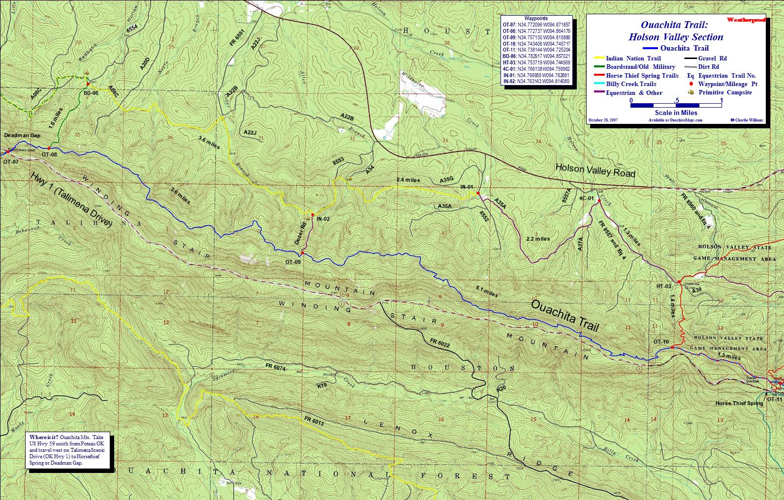
Holson Valley Map: The first map is the Holson Valley Section of the Ouachita Trail (also see the Holson page). While this map is based on the USGS 7.5 minute quads, I shrunk it to 2 inches per mile (rather then 2.64 in/mi the equnialnt of 1:2000) to fit it on one sheet of 11x17 paper.
Though technically not starting until forest road 8552 at waypoint IN-01, there are a couple forest roads, A35a and FR 8557, that connect to the Horse Thief Spring loop (HT-03). This linkage, as well as several others I'll memtion later, can be used for a huge loop of the entire CNT or to turn this section of the Ouachita into smaller loop trails to allow you to hike this section of the OT in smaller bites without the need for a shuttle.
The CNT heads west mostly on its own trail but occasionally using forest roads. Unless it is hunting season, the chances of seeing another person is small. In 2.4 miles, at IN-02, is the dozer road,another opportunity for more looping. This goes straight up the side of the mountain and connects with the OT.
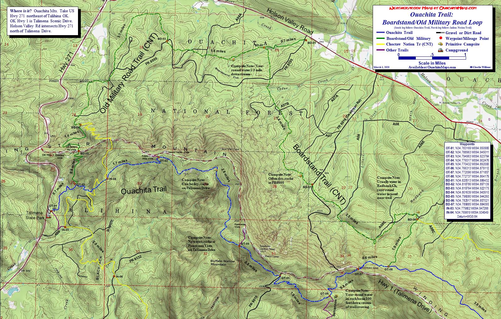
Boardstand-Old Military Loop Map: 3.7 miles later at BD-06 (6.1 total mi), the CNT intersects the Boardstand Trail and we will switch to the Boardstand-Old Military Loop map (also see the Boardstand page). Going west, the CNT and Boardstand share the path for the next 9.8 miles. The Boardstand also goes south on its own at the BD-06 junction and heads up the side of Winding Stair Mountain to the junction of the OT and Boardstand (OT-08). Another opportuntiy for a loop.
Another 2.5 mile further (8.5 total mi), the combined trail crosses FR 6010 at BD-07. This road is also known as Deadman Road because going south it intersects Talimena Drives at Deadman Gap. The intersection is a quarter mile west of OT-07 where the OT crosses the highway. Going north from BD-07, FR 6010 intersects Holson Valley Road. This is one of the few road that cross Winding Stair and can be important for your logistics. This is even more true since a mile west of OT-07 on Talimena Drive, it picks up again and drops down the south side of Winding Stair Mt and intersects with Hwy 63. Hwy 63 is the main east-west road on the south side of Winding Stair. FR 6010 also crosses the CNT at IN-08.
Back to BD-07, the combined Boardstand-CNT heads north-northwest for 2.6 miles in BD-02 (11.1 total mi). This is the junction with the Holson Valley trailhead spur. It is 0.7 miles to the trailhead (BD-01). There are no services but plenty of parking, no permits are required and it is free.
Heading west you are now on the combined Old Military Road trail and CNT. It is still part of the Boardstand-Old Military Loop. The next waypont is BD-03 at FR 6555, in 1.6 miles (12.7 total mi). FR 6555 intersects the trail several times as you head west. It also connects with the Holson Valley Road. In 3.1 miles is BD-04 (15.8 total mi). This is where the CNT leaves the Boardstand-Old Mil loop and travels by itself up to Talimena Drive and further on to the OT.
The multi-use nature of the CNT it evident in the up-hill after BD-04. The numerous switchbacks makes the steep trail a little more tolerable for bikes. After 1.3 miles cross Talimena Drive. In another 0.7 the CNT intersects the OT for the first time at IN-04 (17.8 total mi). Over the next 0.6 miles the CNT weaves back and forth crossing the OT several times keepiing the multi-use trail separate from the hiking-only OT.
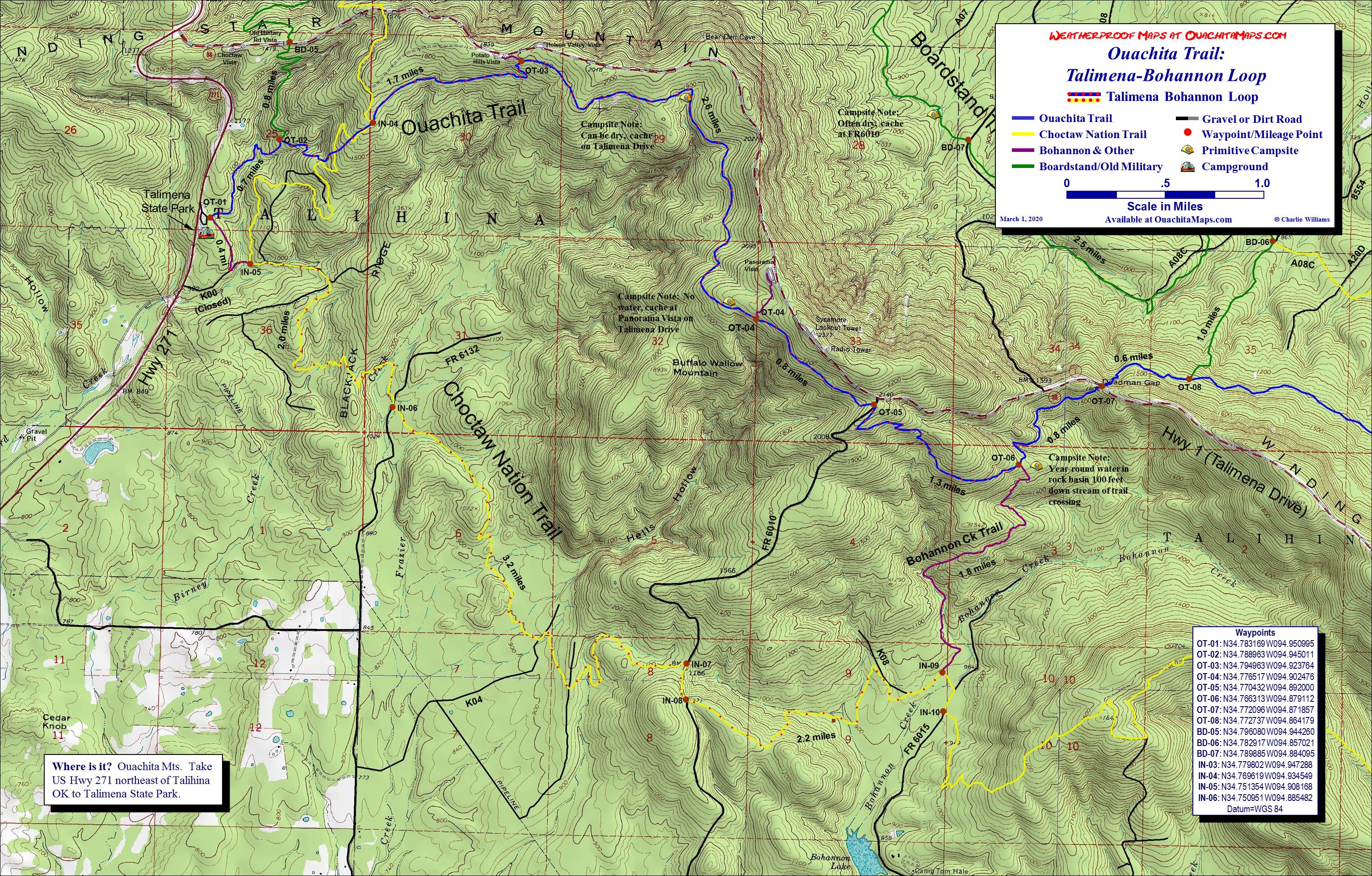
Talimena-Bohannon Loop Map: It is a 2.0 mile downhill from IN-04 to IN-05 (19.8 total mi). This section is covered by the Boardstand-Old Mil map and the Talimena-Bohannon Loop map (also see the Talimena-Bohannon page). When we have hiked the Tal-Bo loop we have sometimes stayed on the OT going from IN-04 to OT-02 to OT-01 to IN-05. If we parked at Holson Valley (BD-01) we could go from BD-04 to BD-05 to OT-02 to OT-01 to IN-05. We have also used the IN-05 to OT-01 alternative to access Talimena State Park. Camping and parking there is fee. Camping in the park is by reservation but if necessary you can probably find a place in the woods well away from the campground.
Back on the CNT, it will run solo until the trail ends at Billy Creek. From IN-05 to IN-06 is 1.9 miles over Blackjack Ridge (21.7 total mi). IN-06 is the crossing on FR 6132 which can be accessed from Hwy 63 or Hwy 271. Turn south to pick up the trail heading to the east. Another 3.2 miles takes you to IN-07 and FR 6010, Deadman Road (24.9 total mi). Part of this section is shared by forest roads, other parts are single track through the woods. At K04 the trail jogs to the north. Follow it a few hundred feet where it leaves the road and turns east.
At IN-07 turn south on FR 6010 and go to the top of the hill to IN-08 (0.2 mi, 25.1 total mi). A new forest road comes in from the east. Follow it along the ridge until the road turns south. You go downhill to the north. At the bottom of the hill is a creek where we have had luck with both water and a place to camp.
The next waypoint is IN-09 where the Bohannon Creek Trail comes in from the north (2.0 mi, 27.1 total mi). This is another one of the connectors with the OT and is part of the namesakes of the Talimena-Bohannon Loop. That loop follows the OT from Talimena State Park to OT-06 and the Bohannon Creek campsite, down the Bohannon to the CNT, and then back to the state a park on the CNT. Be aware that the Bohannon is very rocky.
Back at IN-09 you will head south, pick up FR 6015 for a tenth of a mile then leave the road to the east at IN-10 (27.4 total mi). This area is just north of Bohannon Lake and Boy Scout Camp Hale.
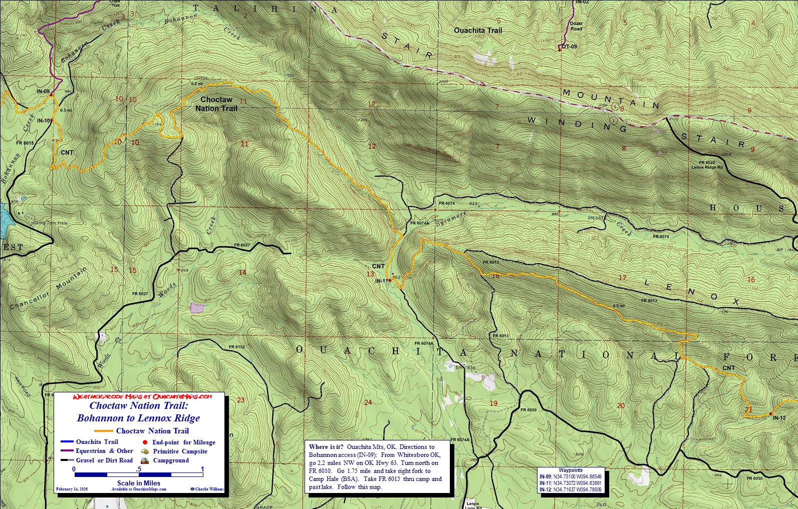
Bohannon to Lennox Ridge Map: From IN-10, the trails follows a forest road for about 0.7 miles then turns east uphill into the forest. It climbs 700 feet, follows the top of a ridge and then drops into the valley of Sycamore Creek. The 5.2 mile section ends at IN-11 (32.6 total mi). We found water and a good campsite in the valley (video).
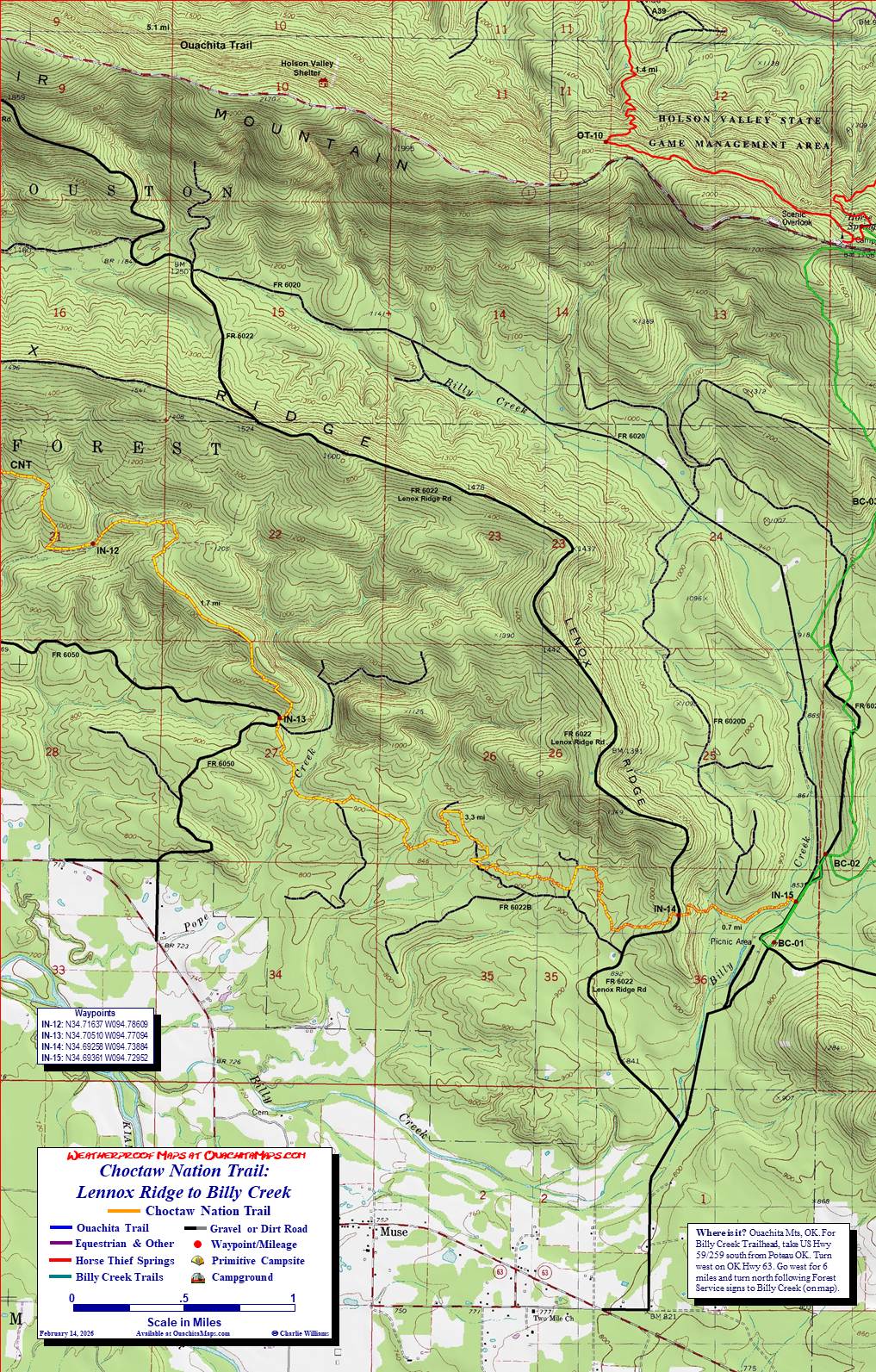
The next section to IN-12 is along south side of Lenox Ridge. The 4.5 mile leg starts with a 500 foot climb, runs level for a mile then works is way down to a small drainage that becomes Briar Creek. Total miles to IN-12 are 37.1.
Lennox Ridge to Billy Creek Map: This last section of the CNT startes with a 200 foot climb 200 feet out of the Briar Creek drainage to 1100 feet and follows a low ridge for 1.7 mile to IN-13 (38.9 total mi).
The next 3.3 miles is through the forest bumping over several small hills ending a IN-14 and the Lenox Ridge Road (42.2 total mi). The trail drops down a 100 foot slope to Billy Creek and in 0.7 miles ends at the Billy Creek Road. Total length is 42.9 miles. Turn right for the Billy Creek parking area and the drive-in campground.
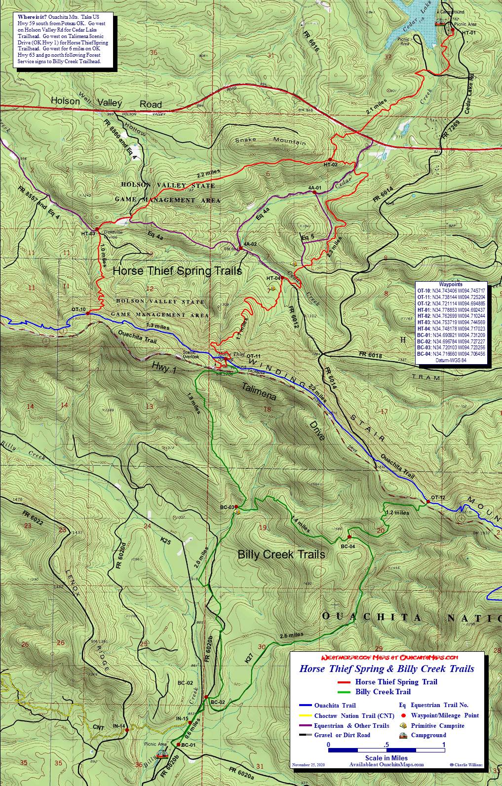
Horse Thief Spring-Billy Creek Map: What if, just what if, you left your car at on the Holson Valley Road or you want to make a big loop. IN-15 is at the Billy Creek Trail and will take you there via the Horse Thief trail (also see the Horse Thief Spring-Billy Creek page). Go it north and take the west trail at BC-02. But for some minor hills, it stays fairly level for 2.0 miles to BC-03. From there it is a 700 foot uphill to Talimena Drive. Cross it to get to Horse Thief Spring. Although there are some other options, the most direct and shortest route back to IN-01 is to take the OT to the west spur of the Horse Thief loop, OT-10. Go one mile north and down hill to Goldville Divide, HT-03. Head northwest on FR 8567-Equestrian 4 for 1.3 miles (purple on the maps). At the HT-03 of the Horse Thief map you are back on the Holson map. 4c-01 is the junction with A35A. Go southwest and follow the road over a small ridge where it will turn north west. At the next junction, go right several hundred feet to IN-01, the beginning of the CNT.
The trip across the Winding Stair Mountain from IN-15 to IN-01 is 10 miles making the total loop 52.9 miles.
Info: USGS 7.5 minute quadrangle topographic maps: LeFlore SE, Blackjack Ridge, Whitesboro, Muse, Big Cedar and Hodgen (trails not shown). Contact Talimena State Park at (918) 567-2052. Contact the Ouachita National Forest, Choctaw Unit, Hodgen OK, at (918) 653-2991.
Directions to Holson Valley: Holson Valley Road runs east-west in the valley north of Winding Stair Mountain. The west end intersects Hwy. 271 10 miles north of Talihina OK, or 13 miles south of the intersection of US Hwy 271 and US Hwy 270. The east end can be accessed from US Hwy 59 10 miles south of Heavener OK. IN-01 is on FR 8552/AG35G, which is 9.8 miles from US Hwy 59 and 10.5 miles from US Hwt 271.
To Buy Maps: All six maps are available either together or individually on color, 11x17 weatherproof paper for $5 each plus S&H by emailing Charlie at cew5151@gmail.com (copy and paste in your email).