Trail Between the Lakes, Sabine National Forest, Texas
Free downloadable topo maps. Available for purchase.
The Trail Between the Lakes is a 28 mile hiking trail in East Texas. Located in the Sabine National Forest, it runs from Lakeview Recreation area on Toledo Bend Reservoir to Highway 96 near the Sam Rayburn Reservoir. The trail was built in the late 1980s and is the result of a joint effort between the Sierra Club and Forest Service. The trail is marked with 2-by 4-inch rectangular aluminum tags. Mile markers begin at Lakeview and count up from east to west.
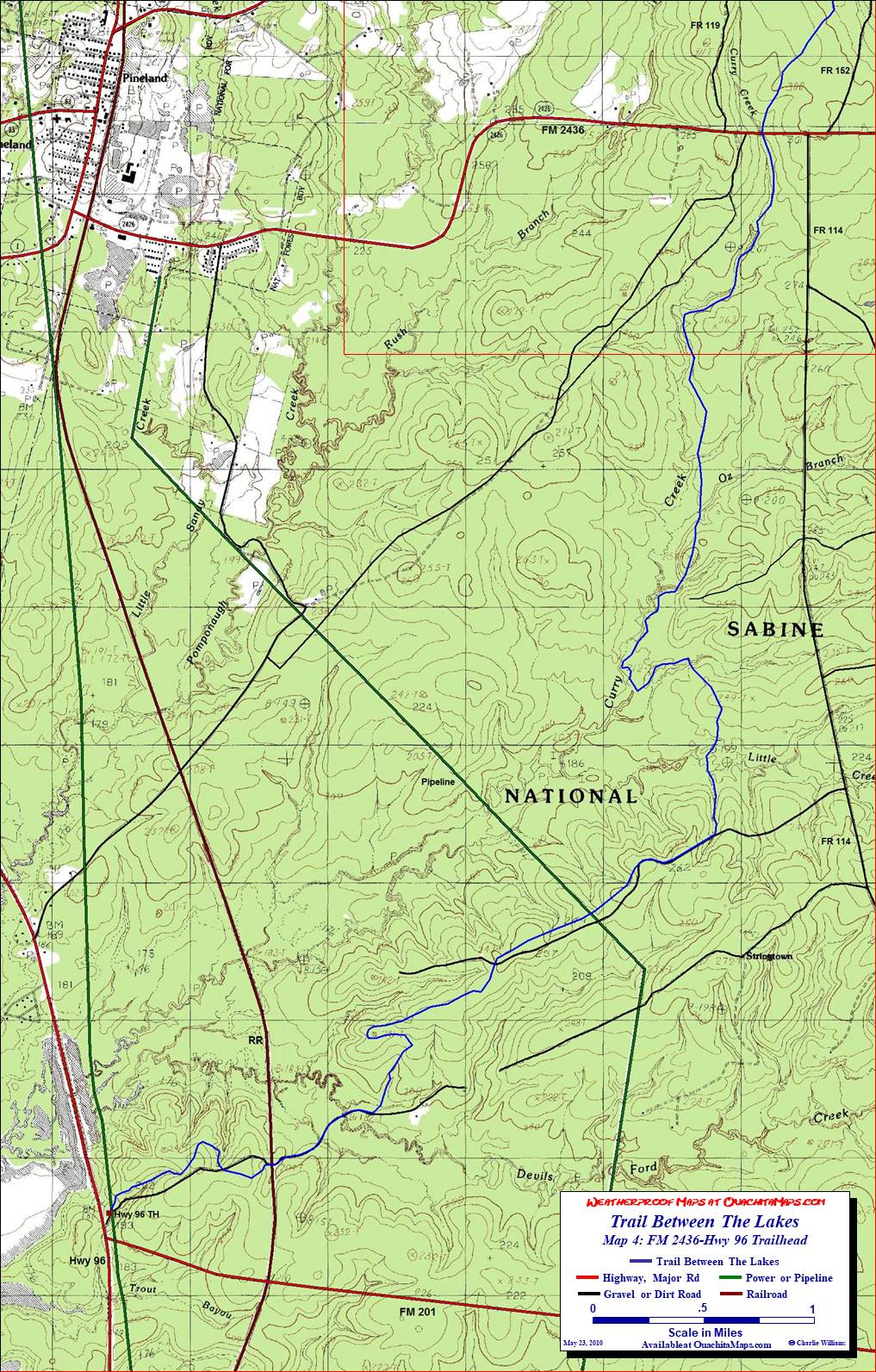
The Maps: There are five FREE maps on this page. Each are true 1:24,000 scale based on the USGS 7.5 minute quadrangles. The Area map is the entire area in one map that provides continuity across the forest that the train maps don't have. The four trail maps are Map 01, Map 02, Map 03 and Map 04. These are pre formatted to print on 11x17 paper. Alternatively, they are available on 11x17 Rite in the Rain weatherproof stock for $5/sheet ($20 for the set) plus S&H. Email cew5151@gmail.com.
All of the maps have been enhanced. The highways and major Farm to Market roads are shown in red, other roads in black, power lines and pipelines in green and railroads in maroon. Google Earth was used to check the roads and add some lesser forest roads that don't appear on the topo. The roads have also been labeled.Trail Mileage. Click here for an Excel spreadsheet of the trail. There is an West to East and East to West version so it is ready to use regardless of your route. Since it is a "live" file you can sum your mileage to get a better idea of the length of your days. Check out column "C." By copying the formula in one of the cells to the beginning and ending location of a day and deleting the formulas in between, you can get subtotals.
GPS File: Right click this link to download the track in a gpx format. Save it to your computer and use your GPS software to load it to your GPS.
Google Earth Tracks: This link is to a Google Earth KML file for all the tracks on the Area map. You should be able to right click the file and save it on your computer. Then open it with Google Earth to see the trail system in interactive 3-D.
Background. Welcome to the Piney Woods of East Texas. This is home of the endangered red-cockaded woodpecker and eight other woodpecker species. As part of the Southern Tertiary Uplands eco-region, it is flat with a few small hills. The natural forest is longleaf pine with hardwoods such as hickory, oak, beech and magnolia. Before the massive pine harvests of the earlier centuries and 100 years of fire suppression, the understory of blue stem grasses created a park-like savanah. It was said that a rider could gallop his horse through the open forest. Not any more. While there are some areas where the historical ecology is coming back, most of the pines are now shortleaf or loblolly found in plantations and the understory is filled with bushes.
While the trail is on national forest lands, there is plenty of evidence of civilization as the trail crosses many roads, pipelines and transmission line right of ways. The good news is that since the Forest Service does not recommend drinking the water (even if filtered), there are ample opportunities to cache water.
If you are unfamiliar with this part of Texas, you will be pleasantly surprised with the mild weather that is typical of winter (IMO the best time to hike in East Texas). It should also be noted that the summer can be VERY hot and humid and quite uncomfortable if you aren't used to it.
The Hike. We hiked this trail in January, just about a year after the space shuttle Columbia disintegrated over East Texas. I bring this up because when we got to our hotel late Friday after our drive from Tulsa, we saw dozens of pictures of debris that had landed in the hotel parking lot.
Our trip was from west to east, starting from the Hwy 96 trail head. We spent 2 nights on the trail taking a short day out so we have time to drive back to Oklahoma. Since this trip was before I started OuachitaMaps, I don't have any pictures from the trip. For details about the trail, I refer you to the Excel spreadsheet, the topos and this Google Earth KML.
All in all this is similar to the Lone Star and Four C hiking trails. The land is fairly level with only about 200 feet of relief between the high and low points on the trail. Pine trees dominate with some areas being fairly open and others with thick understory. In January, all the creek crossings were fordable.
As noted above, the Forest Service recommends that you don't drink the water from the creeks or lakes, even if it is treated. Drinking East Texas trail water has been debated on the Lone Star Hiking Trail forum where many people who drink it claim no negative effects. We are used to caching water and with all the road crossings, this trip is very convenient. We dropped one car at Lakeview and dropped water on the way back to Hwy 96. What it cost in shuttle time, we made up by not having to pump or look for "good" water.
Info: USGS 7.5 minute Quadrangles: Pineland North, Pineland South, Hemphill and Negreet SW. Sabine National Forest, 5050 Hwy 21 East, Hemphill TX 75948, Telephone: (409) 625-1940.
Direction: From Lufkin TX take Highway 103 east for 40 miles. Turn right (south) on Highway 96 and go 17 miles. Look for the sign for the trailhead. If you get to FM 201, you went about 0.1 miles too far.
To Buy Maps: Color, 11x17 maps on weatherproof paper are available for $5 per sheet ($20 for the set) plus S&H by emailing Charlie at cew5151@gmail.com (copy and paste in your email).