Four C Trail, Davy Crockett National Forest, Texas
Free downloadable topo maps. Available for purchase.
Background: This 19.7 mile hike combines the best of hiking in the piney woods of East Texas; tall pines (loblolly and short leaf), hardwoods (mostly oak) and bayous. The trail is situated in the Davy Crockett National Forest, starts at Ratcliff Lake and ends at Neches Bluff Overlook. It is well developed with foot bridges over major water crossings. Some of the trail follows the old, overgrown rail beds of the former owner, Central Coal and Coke Company (4 Cs). As with all hiking in East Texas, the relief is minimal, generally under 100 feet of elevation change. While water is generally plentiful it is affected by chemical runoff. The USFS does not recommend it for drinking, even if filtered or treated, because of heavy metals. There are plenty of roads available for water caches and lots of places to camp. The trail is marked with white tags. This is East Texas and very hot and humid in the summer. However, when the chill of January is setting in around the country, there is a good chance the hiking will be ideal on the Four C Trail.
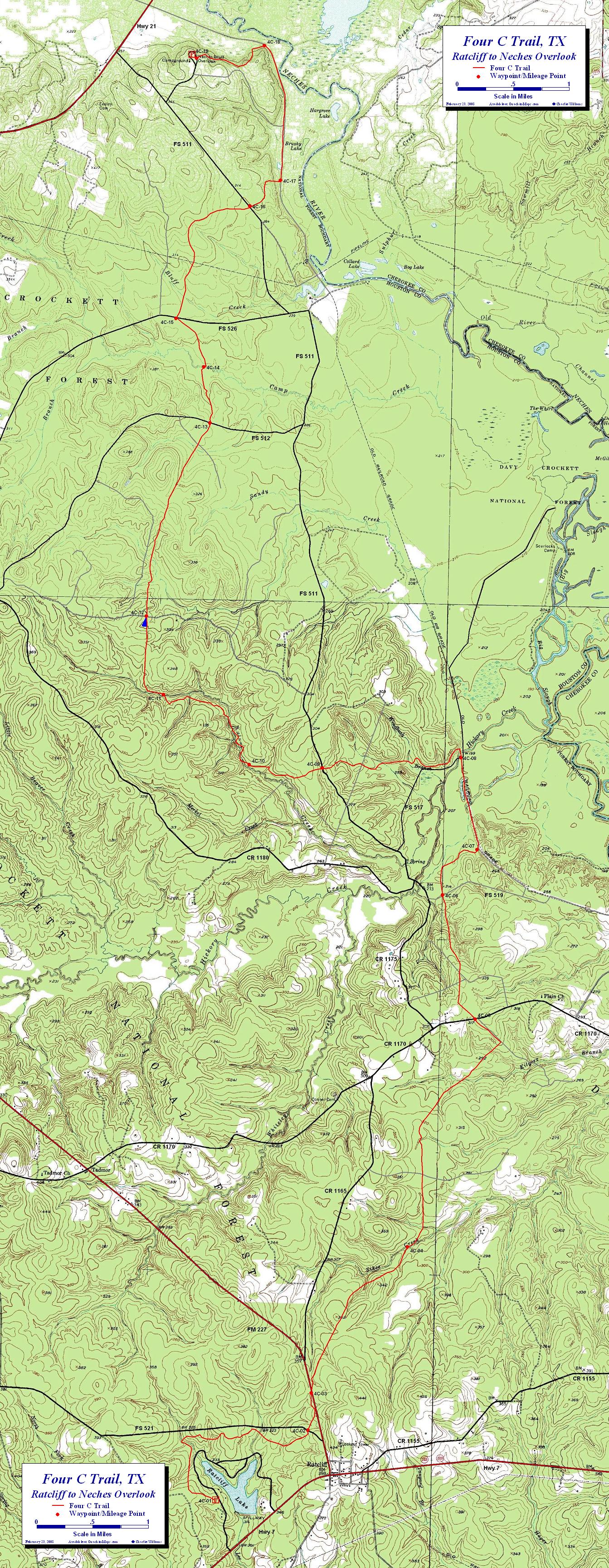
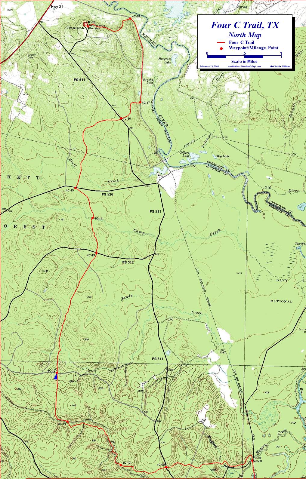
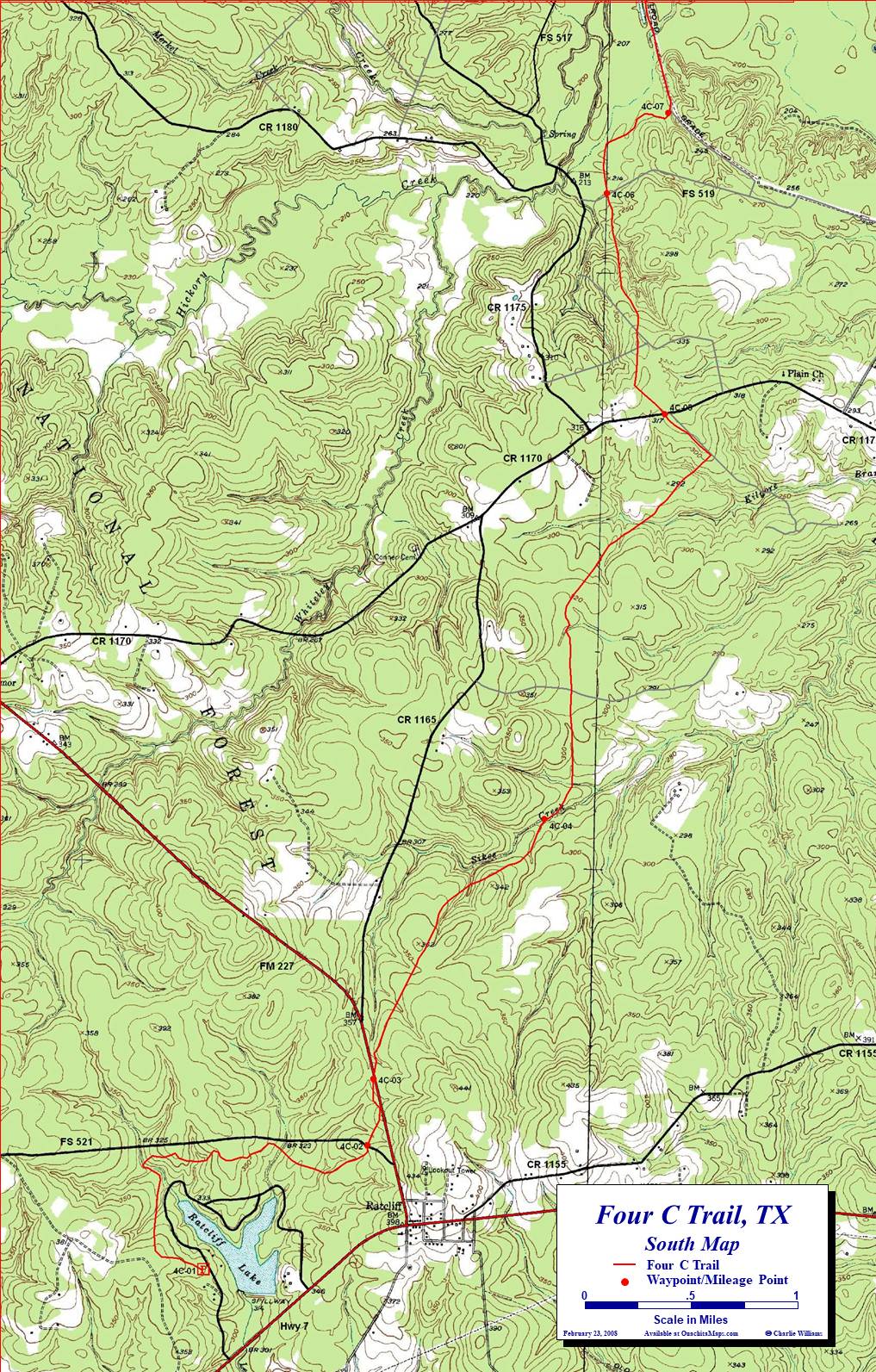
The Maps: There are three FREE maps on this page. Each are true 1:24,000 scale based on the USGS 7.5 minute quadrangles. The Area map is the entire area in one map that provides continuity across the wilderness that the North and South maps don't have. The North Map and the South Map highlight the Four C Trail and are pre formatted to print on 11x17 paper. Alternatively, the North and South maps are available on 11x17 Rite in the Rain weatherproof stock for $5/sheet ($10 for the set) plus S&H. Email cew5151@gmail.com.
The trail is shown in red. The roads have been enhanced and are shown in red/black (highways), black or gray (includes pipelines). Many roads have been added based on the aerial and satellite imagery. Some of the light gray may not be open to vehicles. The waypoints and mileage are described below.
GPS File: Right click this link to download the track in a gpx format. Save it to your computer and use your GPS software to load it to your GPS.
Google Earth Tracks: This link is to a Google Earth KML file for all the tracks on the Area map. You should be able to right click the file and save it on your computer. Then open it with Google Earth to see the trail system in interactive 3-D.
The Four C Trail Description:
- 4C-01, 0.0 miles (N31.388348 W095.156249). Ratcliff Lake Recreation Area trailhead. Ratcliff lake is a 45 acre lake built by CCCC as the site of their sawmill. Car camping is available for a quick start. The trail head is at the north side of the parking lot. Watch out for blue blazes of Tall Pines Trail.
- 4C-02, 2.0 miles (N31.397228 W095.143108). Complete your circuit of Ratcliff and cross Forest Service Road 521.
- 4C-03, 2.4 miles (N31.401862 W095.142698). After walking parallel to it, cross FM 227. This is a paved road, watch for traffic. (FM is Farm to Market, a Texas designation for minor rural roads).
- 4C-04, 3.9 miles (N31.420225 W095.129211). Sikes Creek crossing.
- 4C-05, 6.3 miles (N31.448663 W095.120049). Cross Rd 1170. Follow property line for ¼ mile.
- 4C-06, 7.5 miles (N31.463985 W095.125108). Cross Forest Service Road 519, (aka Big Slough Wilderness Rd) and enter Big Slough Wilderness Area (FS 519 is not on USGS 7.5 minute quads). Big Slough Wilderness is dominated by a variety of oaks and hickory.
- 4C-07, 8.2 miles (N31.469704 W095.120228). After meandering thought the forest, the trail meets and follows the old 4C railroad bed.
- 4C-08, 8.9 miles (N31.481100 W095.122855). Cross Forest Service Road 517 and leave Big Sough Wilderness Area (FS 517 is not on USGS 7.5 minute quads). This is about half way and a good place to cache water for camping. Cross the bridge at Hickory Creek.
- 4C-09, 10.4 miles (N31.479491 W095.142887). Cross FS 511. Go straight.
- 4C-10, 11.1 miles (N31.479719 W095.153501). Primitive shelter on small hill on right.
- 4C-11, 12.3 miles (N31.488192 W095.166116). Cross Walnut Creek, trail heads west along creek for ¼ mile
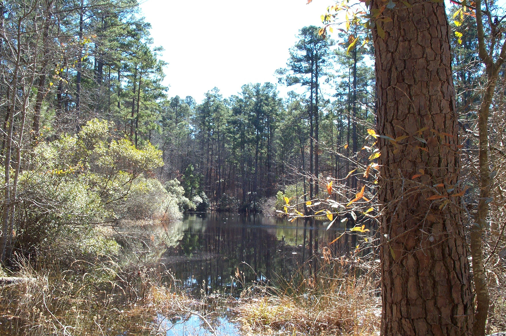
- 4C-12, 13.1 miles (N31.497850 W095.168907). Pond and primitive campsite
- 4C-13, 14.9 miles (N31.522026 W095.160158). Cross FS 512. Go Straight. Good access for water caching.
- 4C-14, 15.4 miles (N31.528962 W095.161202). Cross Camp Creek. Go Straight.
- 4C-15, 16.0 miles (N31.534926 W095.165373). Cross FS 526. Go Straight. Good access for water caching.
- 4C-16, 17.4 miles (N31.549073 W095.154988). Cross FS 511. Go straight.
- 4C-17, 17.8 miles (N31.552294 W095.150607). Intersect gravel road (formerly part of the 4C rail system) and turn left and follow it for 1.2 miles.
- 4C-18, 19.0 miles (N31.569007 W095.153319). Turn left and leave gravel road. Head up north side of Neches Bluff.
- 4C-19, 19.7 miles (N31.567290 W095.163139). Neches Bluff Overlook. Primitive car camping and easy access to Highway 21 via FS 511
Info: The Four C Trail was featured in Waypoints, Backpacker Magazine, December 2006, Midwest Edition. USGS 7.5 minute quadrangle topographic maps are Ratcliff, Kennard NE, and Weches, TX. Contact the Davy Crockett National Forest in Kennard, Texas at (936) 655-2299.
Directions: From Houston, go north on US 59 about 120 miles to Lufkin. Go north on US 69 about 12 miles to State Highway 7. Go west on Highway 7 about 1 mile past Ratcliff. Turn right at the entrance to Ratcliff Lake Recreation. The trailhead is at the parking lot about a half mile up the access road on the left .
To Buy Maps: Color, 11x17 maps on weatherproof paper are available for $5 per sheet ($10 for the set) plus S&H by emailing Charlie at cew5151@gmail.com (copy and paste in your email).